
Tràng An landscape complex
Tràng An landscape complex |
|
|---|---|
|
UNESCO world heritage |
|

|
|
| The Ngô Đồng River with karst formations |
|
| National territory: |
|
| Type: | Nature & culture |
| Criteria : | v, vii, viii |
| Reference No .: | 1438 |
| UNESCO region : | Asia and Pacific |
| History of enrollment | |
| Enrollment: | 2014 (session 38) |


The landscape complex Tràng An ( Vietnamese : Quần thể danh thắng Tràng An ) is located near Ninh Bình in the Vietnamese region of Đồng Bằng Sông Hồng on the southern edge of this delta of the Red River . The geology consists of numerous karst mountains and valleys in a water landscape with partly flooded caves, which are spectacular destinations for tourist boat tours. The exploration of caves at different heights revealed archaeological traces of human habitation from a continuous period of more than 30,000 years.
In addition to the historic Hoa Lư town complex and the Hoa Lư primeval forest area, the landscape complex consists of the Tràng An regions with an ecotourist focus and Tam Cốc-Bích Động , mainly located in the municipality of Ninh Hải (Hoa Lư) and also synonymous with the Tam cốc pagoda complex bích động . On June 23, 2014, Tràng An was named a natural and cultural monument of the UNESCO World Heritage as a picturesque landscape complex at the 38th session of the World Heritage Committee in Doha . This makes it Vietnam's first world heritage site in both categories.
Hoa Lư
In addition to traces of everyday life from 30,000 years of settlement, the landscape complex is home to some special sites in Vietnamese history, such as the historic capital Hoa Lư ( Cố đô Hoa Lư ). In 968, the founder of the Đinh dynasty , King Đinh Bộ Lĩnh , moved the capital of his empire near his birthplace Gia Viễn to Hoa Lư in the municipality of Trường Yên. Here on the Hoàng Long River ( sông Hoàng Long ), in the middle of the dry Halong Bay , it was at a safe distance from the Chinese border, and remained there during the Đinh and early Lê dynasties until 1009.
Tam Cốc and Bích Động
Tam Cốc means 'three grottoes' and denotes the three caves Hang Cả , Hang Hai and Hang Ba . These are traversed by the shallow Ngô Đồng River (sông Ngô Đồng) and are a popular destination for tours, which usually start in the village of Văn Lâm. The rowing women of Tam Cốc , who also offer embroidered goods, are proverbial .
Bích Động , translated Jade Cave or Green Cave, is a flooded dark cave 350 m long and is considered by some to be the most beautiful cave in Vietnam. On the nearby mountain Ngũ Nhạc is the pagoda complex Tam c28c bích động from the year 1428. The complex consists of the three pagodas Hạ , Trung and Thượng .
Chùa Bái Đính
The Bái Đính Temple ( Chùa Bái Đính ) in Gia Sinh Commune (Gia Viễn District) is a complex on around 700 hectares and is currently the largest pagoda complex in Vietnam. One of the numerous other temples and pagodas is the stone temple Đền Trần or đền Nội Lâm , which is said to have been built by Đinh Bộ Lĩnh in 968. A big temple festival takes place there on March 18th of the lunar calendar.
Other attractions nearby are the Thung Nham Bird Park in the village of Đam Khê (Ninh Hải municipality), 2 km from Bích Động, and the Phát Diệm Cathedral in Ninh Bình , consecrated in 1892 . A view of Tam Cốc and Ninh Bình is possible from Mount Hang Múa . The Cúc Phương National Park lies to the northwest.
Photos from Tràng An
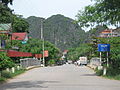
Road bridge in the east of Hoa Lư

Eastern gate of Đinh Bộ Lĩnh Temple ( Đền Vua Đinh Tiên Hoàng ) in historic Hoa Lư

Scene of the annual festival in honor of the Đinh and Lê kings in Đền Vua Đinh Tiên Hoàng
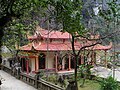
The Hạ Pagoda in the Bích Động complex
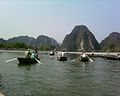
On the Ngô Đồng river near Hoa Lư towards Tam Cốc
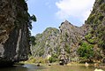
Continue towards Tam Cốc


Web links
- Entry on the UNESCO World Heritage Center website ( English and French ).
- World Heritage website. Trang to Landscape Complex Management Board, Mr. Bui Van Manh, accessed May 16, 2016 .
Individual evidence
- ↑ UNESCO World Heritage 1438. In: UNESCO World Heritage Center. whc.unesco.org, 2014, accessed May 15, 2016 .
- ↑ Hoa Lu, capital of Vietnam from 968-1009. Catalog of the German National Library, accessed on May 15, 2016 .

Cultural heritage: Imperial city of Huế (1993) | Old Town of Hoi An (1999) | Temple city Mỹ Sơn (1999) | Imperial Citadel Thăng Long - Hanoi (2010) | Citadel of the Hồ Dynasty (2011)
Natural heritage: Ha Long Bay (1994) | Phong Nha-Kẻ Bàng National Park (2003)
Cultural / natural heritage: Tràng An landscape complex (2014)
Coordinates: 20 ° 15 ′ 20.5 ″ N , 105 ° 54 ′ 56.2 ″ E