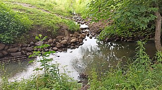
Langenhorstgraben
| Langenhorstgraben | ||
|
The Langenhorstgraben flows into the Kollau |
||
| Data | ||
| location | Hamburg-Niendorf | |
| River system | Elbe | |
| Drain over | Kollau → Tarpenbek → Alster → Elbe → North Sea | |
| source | On the street Lokstedter Holt 53 ° 36 ′ 46 ″ N , 9 ° 57 ′ 1 ″ E |
|
| muzzle | am Kleingartenverein Erlengrund eV 308 in Kollau Coordinates: 53 ° 36 '30 " N , 9 ° 57' 6" E 53 ° 36 '30 " N , 9 ° 57' 6" E
|
|
| length | 600 m | |
| Right tributaries | The Schmiedekkoppel road drainage ditch | |
| Big cities | Hamburg | |
| Navigable | No | |
The Langenhorstgraben is an approx. 600 m long, partially cased trench in Hamburg-Niendorf . It is of great importance for the drainage of the catchment area north of the Kollau.
course
The Langenhorstgraben rises south of the Loksteder Holt road and then passes under the Schmiedekoppel. It flows through a retention basin north of the Langenhorst road , where it also receives an inflow through a ditch coming from the west, which is connected to a drainage ditch on the east side of the Schmiedekoppel. Then it runs parallel on the northern side of the Langenhorn road until it crosses under it almost vertically. The ditch crosses under the Brandfurt street and then flows north of the Kollau hiking trail into the Kollau.
History
Instead of the Langehorstgraben there was an earlier moat further west.
The trench was partially filled in, piped and relocated elsewhere in the course of the construction of the depot of the Hamburg city cleaning service in the Langenhorstgraben. It said:
“The shifting of the Langenhorstgraben in the section of Planstrasse A and the relocation of the north-south section of the near-natural Langenhorstgraben is unavoidable in order to be able to realize the special area and to connect it with traffic. However, a considerably larger area is planned for the laying, so that the proportion of ecologically effective surface water in the planning area is even increasing. "
Web links
Individual evidence
- ↑ Complete list of rivers in the Elbe catchment area. Retrieved June 30, 2020 .
- ↑ a b c Justification for the development plan Niendorf 86. Accessed on July 3, 2020 .
- ↑ Google Maps. Retrieved July 3, 2020 (de-US).

