Le stuff
| Le stuff |
||
|---|---|---|
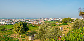
| View of Le Kram and the Gulf of Tunis | ||
| administration | ||
| Country |
|
|
| Governorate | Tunis | |
| Post Code | 2015 | |
| Demographics | ||
| population | 74,132 pop (2014) | |
| Population density | 7197 inhabitants / km² | |
| geography | ||
| height | 10 m | |
| surface | 10.3 km² | |
|
|
||
| Coordinates | 36 ° 50 ′ N , 10 ° 19 ′ E | |
Le Kram ( Arabic الكرم) is a coastal city and a delegation with around 75,000 inhabitants in northern Tunisia .
location
Le Kram lies at a height of approx. 5 to 15 m above sea level. d. M. on the Gulf of Tunis about 14 km (driving distance) east of the state capital Tunis . The archaeological site of Carthage is only 4 km to the north.
economy
Le Kram is one of the many satellite cities in the capital Tunis, where most of the residents earn their living.
history
For centuries the place was nothing more than a fishing village. Ahmad I. al-Husain , the Bey of Tunis, gave the place and its fruit-tree-covered hinterland to his war minister Agha in the middle of the 19th century ; the place name Kram El Agâ was created . Many Europeans settled here during the French protectorate over Tunisia (1881–1956). Only in the second half of the 20th century did a steadily increasing population growth due to immigration from rural areas set in, initially slowly. Until 2001, Le Kram belonged to the municipalité of the neighboring town of La Goulette .
Attractions
Apart from the waterfront, on which there are still a few colonial mansions, and the nearby archaeological ruins of Carthage, Le Kram offers no sights.

