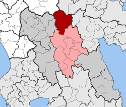
Levidi
|
Levidi municipal district Δημοτική Ενότητα Λεβιδίου (Λεβίδι) |
||
|---|---|---|
|
|
||
| Basic data | ||
| State : |
|
|
| Region : |
Peloponnese
|
|
| Regional District : | Arcadia | |
| Municipality : | Tripoli | |
| Geographic coordinates : | 37 ° 41 ′ N , 22 ° 17 ′ E | |
| Height above d. M .: | 860 m (average) |
|
| Area : | 312.641 km² | |
| Residents : | 3,094 (2011) | |
| Population density : | 9.9 inhabitants / km² | |
| Code No .: | 400104 | |
| Structure: | 11 local communities | |
| Located in the municipality of Tripoli and in the Arcadia regional unit | ||
Levidi ( Greek Λεβίδι ( n. Sg. )) Is a village with 1025 inhabitants in Arcadia on the Peloponnese in Greece .
Until 2010 Levidi was an independent municipality, since 1947 a municipality (dimos), which had grown to about 4,000 inhabitants through incorporation in 1997. On January 1, 2011, the municipality of Leonidi was incorporated into Tripoli , where it has since formed a municipality.
Around five kilometers north of Levidi lies ancient Orchomenos on a ridge .
A museum in Levidi is dedicated to the politician Alexandros Papanastasiou .
A few kilometers from Levidi, on the Menalo , there is a winter sports area.
Individual evidence
- ↑ Results of the 2011 census at the National Statistical Service of Greece (ΕΛ.ΣΤΑΤ) ( Memento from June 27, 2015 in the Internet Archive ) (Excel document, 2.6 MB)

