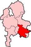
Lichfield District
| Lichfield District | |
|---|---|
 Location in Staffordshire |
|
| status | District |
| region | West Midlands |
| Administration County | Staffordshire |
| Administrative headquarters | Lichfield |
| surface | 331.30 km² (149.) |
| Residents | 97,500 (232.) |
| ONS code | 41UD |
| Website | www.lichfielddc.gov.uk |
Lichfield is a district in the county of Staffordshire in England . The administrative seat is the city of the same name Lichfield . Another important place is Burntwood .
The district was formed on April 1, 1974 and was the result of the merger of the Municipal Borough of Lichfield and most of the Rural District of Lichfield. The town of Burntwood makes up most of the county.
Coordinates: 52 ° 41 ′ N , 1 ° 50 ′ W