
Lindenplatz (Lübeck)


The Linde space is a space and the name of the directly associated street in Lübeck .
location
Lindenplatz is located west of Lübeck's old town in the St. Lorenz district . Its eastern half takes a roundabout into which the Fackenburger Allee converge from the north and Moislinger Allee from the south ; the Puppenbrücke leads to the east, in the direction of Holstentor and the old town . The western half forms an almost triangular green area through which Konrad-Adenauer-Straße , in this section reserved for pedestrians and cyclists, leads to the main station . The street that borders this park to the west and south is counted as part of the square and therefore bears the same name.
history
Originally, Lindenplatz neither had its own name, nor did it have a special character; it was simply a place outside the city fortifications, where several streets came together. In the late 18th century, the wealthy owners of the summer houses along Moislinger and Fackenburger Allee began to beautify the access routes to their second homes at their own expense by planting rows of linden trees on the roadsides . As a result, the later Lindenplatz received its first specific design around 1780. Some of the linden trees planted there were still there in the 1930s.
In the 19th century, the horse markets were temporarily held on the still nameless square, as the grassy open spaces were ideal for this. A number of the iron rings that were put around the trees to tie the animals were still preserved in 1934.
In 1869 the square was officially named Lindenplatz after the tree population , and in 1884 it was redesigned into a jewelry square by the city gardener Metaphius Theodor August Langenbuch . The lavish park was equipped with around 100 species of mostly foreign trees and bushes, giving it the character of a generally accessible botanical garden . However, a large part of the carefully designed park had to give way again when the new central station was built in 1905–1908. The remaining green area still exists today in a greatly simplified form.
In the 1920s, the place where several important roads converged became a traffic junction at which the increasing motor traffic was concentrated. Two petrol stations were built, in the middle of Lindenplatz a traffic policeman was constantly posted to regulate the increasing traffic , who from 1925 had a wooden tower over 2 meters high as a platform.
In 1928, Linde course was in honor of the three years before the late first Reich President in Friedrich-Ebert-Platz renamed. In the wake of the seizure of power by the National Socialists , the name was again changed to Danziger Freiheit . In keeping with the new name, a large mosaic of the Gdańsk coat of arms made of colored paving stones was placed in the center of the square.
With the end of the Third Reich , the name changed again to the name that was used until 1928 and has remained unchanged since then. In 1959, the road junction in the eastern part of Lindenplatz was redesigned into a multi-lane roundabout, which has been a problematic focus of accidents for years due to its confusing and particularly irritating traffic management.
buildings
- Bismarck monument by Emil Hundrieser (1903), located in front of the Holsten Gate until 1934
- Equestrian statue of Kaiser Wilhelm I , made in 1921 as the last imperial monument in Germany and only erected there in 1934
photos

The Lindenplatz park, laid out in 1882, before its extensive removal in 1905, as seen from the Puppenbrücke
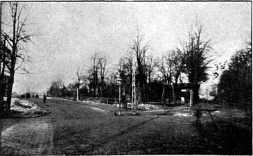
The Lindenplatz again from the direction of the Puppenbrücke, but after the changes in 1905; on the right the Fackenburger Allee, on the left today's Konrad-Adenauer-Straße without the station building, which today stands at its end

Laborious pharmacy building
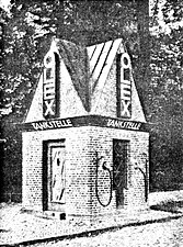
The first petrol station built for OLEX in 1924 on Lindenplatz
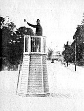
The traffic tower on Lindenplatz, 1925


literature
- Klaus von Beyme (ed.): New cities from ruins. German post-war urban development. Prestel, Munich 1992, ISBN 3-7913-1164-6 .
- W. Brehmer : The street names in the city of Lübeck and its suburbs. HG Rathgens, Lübeck 1889.
- Max Hoffmann: The streets of the city of Lübeck. In: Journal of the Association for Lübeck History and Archeology. Jg. 11, 1909, ISSN 0083-5609 , pp. 215-292 (also special print: 1909).
- W. Stier: On the history of the former Lindenplatz and its facilities. In: Heimatblätter. Messages from the Association for Homeland Security, Lübeck. No. 113, June 10, 1934, ZDB -ID 536851-0 .
- The traffic tower on Lindenplatz in Lübeck. In: Heimatblätter. Messages from the Association for Homeland Security, Lübeck. No. 14, 10.
Web links
See also
Coordinates: 53 ° 51 ′ 59.5 " N , 10 ° 40 ′ 28.1" E