
Fackenburger Allee


The Fackenburger Allee is a street in Lübeck .
location
The about 1.52 kilometers Fackenburger Avenue begins at Lindenplatz near the Puppenbrücke and moving toward the northwest until it at an intersection shortly before the transfer of the federal highway 1 in the Krempelsdorfer Allee passes.
history
Fackenburger Allee was built in the early days of Lübeck in the 12th century as a country road that led from the Holstentor into northern Holstein to Eutin . However, the street did not have a fixed name for a long time. It was not until 1869, when the previously unnamed streets in the Lübeck suburbs were officially named, that they got their name, which has not changed to this day. The name refers to the village of Fackenburg , which was only founded in 1751 , which was on the road just across the Lübeck border and which has now completely merged into Stockelsdorf .
Until the 1860s , the street was only sparsely lined with buildings; In addition to a few summer houses , there were mainly market gardens and farms . It was only after the gate was closed in 1864 that the suburbs could grow, which was also noticeable in the area of Fackenburger Allee and in the wake of which a number of Wilhelminian-style residential buildings were built, a number of which are still there today. The beginning of industrialization led to the construction of commercial buildings like the WFL Beth machine factory until the First World War .
The Prussian rearmament led to the old barracks built in 1868, acquired by the Deutsche Bundespost in 1970 and finally demolished by it in 1976, which was probably one of the most defining buildings on the street.
The dairy cooperative founded in 1889, later known as HANSANO , moved its headquarters from the parade in front of the former gates of the city not far from the Beth'sche machine factory in 1900. She wasn't supposed to leave him until 1995.
The new main station
Around 1905, the appearance on the other side of the Trave and the moat changed significantly . Nobody would recognize the adjacent Lindenplatz as such today.
The earthworks required for the new station in the suburb of St. Lorenz have been carried out. So the front part had to be raised by 1.80 m. The steepest slope is 1:35, the roadway width was planned to be 15 m and was paved with Belgian porphyry stones. For the footpaths, 5 m wide paved paths were built, which were provided with concrete underlay and curbs . The street was bordered on both sides by a row of trees. The required soil was brought in from the area behind the Schützenhof restaurant .
As a result of the redesign of the station, it became necessary to build a road bridge over the railway body. At that point, the road runs over the tracks at an altitude of 11.20 NN . Architecturally, the bridge was once provided with wrought iron railings and richly constructed end pylons . The bridge is around 73 m long and 18 m wide, of which 11 m is accounted for by the road and 3 ½ m each by the sidewalks . Two tram tracks ran across the bridge in the middle. The roadway on the bridge was made of Kieferling basalt cement plaster . 14 (currently nine) tracks ran under the bridge. Numerous gas, water, light and postal cables, as well as those of the police and fire brigade, had to be relocated.
After completion, the tram from Lindenplatz to Hermannstrasse ( Schwartauer Allee line ) to the Black Eagle ( Krempelsdorf line ) was expanded to two tracks.
Since the traffic in the suburbs will increase considerably after the opening of the station, two new facilities had already settled here. In the large building on the bridge there was a branch of the Lübeck savings and loan cash register and a post office had already been created in Fackenburger Allee .
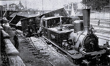
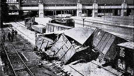
On May 29, 1908, it became clear that not everything was going optimally. When a 118-axle freight train of the Eutin-Lübeck Railway, hauled by two locomotives , left the main station in the morning , it drove under the footbridge over the Fackenburger Allee instead of the Eutin track in the harbor track . Here he was off the tracks forced out . People were not harmed in the process , but the damage to property was considerable.
- Railway accident at the Lübeck train station


During his years in Lübeck, Wilhelm Furtwängler was a resident of Fackenburger Allee No. 2.
The military firing range
When they foresaw what advantage it afforded in trouble when both the able-bodied and citizens are familiar to weapons conscripts with the leadership of the weapons, it briefed the ahead of the Holsten Schützenhof for practicing the disc shooting in the middle of the 16th century. a.
Due to inadequate protective measures for public safety and constant collisions between various practicing citizens' colleges, a separate shooting range was created for the 19th century Luebian contingent .
The sand pits next to Fackenburger Allee between the so-called Verderb and the Lohmühle served as this . Two nearby mountains of targets served as bullet traps from which the shooting range was 200 paces away. In the absence of other protective devices, it was not surprising that the owners of the surrounding gardens and fields - especially the Lohmüller - complained about the dangers of bullets flying over or ricocheting off. The military department responded on August 8, 1836.
Under the direction of the major Niemeitz by was fascines mounted groundwall increased and turf constructed. The shooting range was enclosed with trenches and provided with a barrier .
After the needle gun was introduced in 1861 , the Scheibenberg was raised to 32 feet to deal with the impending discomfort.
With the development of weapons, the intensity of the training increased. In 1849 and 50 the old Schützenhof was again forced to use it for short distances. The railway, which was extended to 350 paces in 1847, remained in Fackenburger Allee for further distances.
In 1852, on the initiative of Major Behrens, the facility was expanded one last time. A second shooting lane was created next to the first, both 400 paces long. These were separated by an earth wall 13 to 14 feet high. The Scheibenberg was raised to 38 feet and widened by 65 feet. Small shooting galleries were set up to protect the riflemen.
With the conclusion of the military convention with Prussia of 1867, the square passed into the hands of the Prussian military administration and then that of the Reich . This used it until new shooting ranges were set up in the Wesloer Tannen (1904).
On February 14, 1910, the citizenship agreed to a contract with the Reich Military Administration, according to which, in exchange for the surrender of a piece of land for the new machine gun company (MGK) next to the Marli barracks, the area of the old military shooting range on Fackenburger Allee returned to the property of the after almost two generations Lübeck state passes over.
literature
- W. Brehmer : The street names in the city of Lübeck and its suburbs. HG Rathgens, Lübeck 1889.
- Max Hoffmann: The streets of the city of Lübeck. In: Journal of the Association for Lübeck History and Archeology. Jg. 11, 1909, ISSN 0083-5609 , pp. 215-292 (also special print: 1909).
Web links
See also
Individual evidence
- ↑ According to the consumer service of Arla Foods GmbH , to which HANSANO has belonged since 2011, the decisive factors were the “size of the property and the increasing urbanization in this area”.
- ^ The structural changes in the suburb of St. Lorenz. In: Vaterstädtische Blätter , November 26, 1905, ISSN 0724-1410 .
- ↑ Weekly Chronicle. In: Vaterstätische Blätter , No. 22, year 1908, edition of May 31, 1908, p. 88.
- ↑ see here
- ↑ The military firing range on Fackenburger Allee. In: Vaterstädtische Blätter , February 27, 1910.
Coordinates: 53 ° 52 ′ 19.2 ″ N , 10 ° 40 ′ 2.9 ″ E