List of ground monuments in Vorra
The archaeological monuments of the Middle Franconian municipality of Vorra are compiled on this page . This table is a partial list of the list of ground monuments in Bavaria . The basis is the Bavarian Monument List , which was first drawn up on the basis of the Bavarian Monument Protection Act of October 1, 1973 and has since been managed by the Bavarian State Office for Monument Preservation . The following information does not replace the legally binding information from the monument protection authority.
As of July 3, 2018, 20 ground monuments from Vorra are registered in the Bavarian list of monuments.
Notes on the information in the table
- Name, designation column : Designation of the listed property
- District column : District in which the listed property is located
- Coordinates column : Geographical location
- Monument number column : Official monument number of the Bavarian State Office for Monument Preservation
- Column -time job : Special data so far known or derivable partly date of first mention of the property
- Monument scope column , comment : More detailed explanations about the monument status, the scope of the property and its special features
Except for the picture column , all columns can be sorted.
List of ground monuments
| Name, description | District | Coordinates | Monument number | Time position | Monument scope, remark | image |
|---|---|---|---|---|---|---|
| Cave station of prehistoric times | Alfalter / Pommelsbrunn | 49 ° 32 '50.97 " N , 11 ° 29' 1.44" E | D-5-6434-0101 | Brunnerschacht (A 129) in the forest area "Fichtig". Ground monument crossing the municipal boundary to Pommelsbrunn. | ||
| Section reinforcement of prehistoric times | Supply | 49 ° 33 '22.98 " N , 11 ° 29' 0.44" E | D-5-6434-0131 | Section fortification Bürg | ||
| Burial mound of prehistoric times | Supply | 49 ° 34 '10.48 " N , 11 ° 28' 30.94" O | D-5-6434-0132 | Grave mound on the Scheinleite | ||
| Fortification of prehistoric times | Supply | 49 ° 34 '0.28 " N , 11 ° 28" 44.41 " E | D-5-6434-0136 | Fixing on the Schönbühl | ||
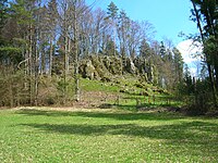
| Medieval castle stable | Alfalter | 49 ° 33 '9.1 " N , 11 ° 27" 20.92 " E | D-5-6434-0138 | Probably built during the 11th or 12th century | Burgstall Old Castle |
 more pictures |
| Settlement of the Urnfield Period | Alfalter | 49 ° 32 '8.57 " N , 11 ° 28' 2.06" E | D-5-6434-0140 | Located south of Alfalter in the Pegnitz Valley | ||
| Settlement of the Urnfield Period | Alfalter | 49 ° 32 '40.12 " N , 11 ° 28" 21.92 " E | D-5-6434-0141 | Located northeast of Alfalter in the Pegnitz Valley | ||
| Settlement of the Urnfield Period | Alfalter | 49 ° 32 '30.79 " N , 11 ° 28' 7.27" E | D-5-6434-0143 | Located northeast of Alfalter in the Pegnitz Valley | ||
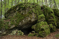
| Cave station from the Hallstatt period and the Middle Ages, graves from prehistoric times | Artelshofen | 49 ° 34 '51.7 " N , 11 ° 29' 27.01" O | D-5-6434-0148 | Marderloch (A 11) |
 more pictures |
|
| Place of sacrifice of the Bronze and Urnfield Ages | Artelshofen | 49 ° 34 '59.74 " N , 11 ° 29" 12.54 " E | D-5-6434-0149 | |||
| Cave station of prehistoric times | Alfalter | 49 ° 32 ′ 48.28 " N , 11 ° 28 ′ 12" E | D-5-6434-0155 | Cave in the forest corridor "Am Eicha" | ||
| Cave station of prehistoric times | Alfalter | 49 ° 32 '46.22 " N , 11 ° 28" 10.35 " E | D-5-6434-0156 | Cave in the forest corridor "Am Eicha" | ||
| Fortification of prehistoric times | Supply | 49 ° 33 '57.55 " N , 11 ° 27' 56.97" O | D-5-6434-0192 | Fixing on the Langenstein | ||
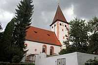
| Medieval and early modern findings in the area of the Evangelical Lutheran parish church of St. Maria | Supply | 49 ° 33 '28.56 " N , 11 ° 29" 40.07 " E | D-5-6434-0193 | Church of St. Mary | ||
| Medieval and early modern findings in the area of the Evangelical Lutheran Church of St. Catherine | Alfalter | 49 ° 32 '25.53 " N , 11 ° 28' 4.59" E | D-5-6434-0195 | Church of St. Catherine | ||
| Medieval and early modern findings in the area of the Evangelical Lutheran parish church of St. Philip and James | Artelshofen | 49 ° 34 '23.37 " N , 11 ° 29' 50.4" E | D-5-6434-0197 | Church of St. Philip and James | ||
| Medieval moated castle and early modern castle | Artelshofen | 49 ° 34 '24.12 " N , 11 ° 29" 49.57 " E | D-5-6434-0198 | Artelshofen Castle | ||
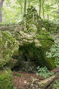
| Cave station from the Urnfield period | Supply | 49 ° 33 '56.3 " N , 11 ° 31' 17.69" O | D-5-6435-0024 | Hirschberg Cave (A 324) |
 more pictures |
|
| Body graves from the Hallstatt period | Artelshofen | 49 ° 34 '20.88 " N , 11 ° 29" 57.89 " E | D-5-6435-0025 | |||
| Cave station of prehistoric and medieval times | Supply | 49 ° 33 '50.7 " N , 11 ° 30' 2.45" E | D-5-6435-0030 | Cave on the west side of the "Diedesbühl" |
See also
Web links
- List of monuments for Vorra (PDF) at the Bavarian State Office for Monument Preservation
- Bavarian Monument Atlas (cartographic representation of the Bavarian architectural and ground monuments by the BLfD , requires JavaScript)
Remarks
- ↑ This list may not correspond to the current status of the official list of monuments. The latter can be viewed on the Internet as a PDF using the link given under web links and is also mapped in the Bavarian Monument Atlas . Even these representations, although they are updated daily by the Bavarian State Office for Monument Preservation , do not always and everywhere reflect the current status. Therefore, the presence or absence of an object in this list or in the Bavarian Monument Atlas does not guarantee that it is currently a registered monument or not. The Bavarian List of Monuments is also an information directory. The monument property - and thus the legal protection - is defined in Art. 1 of the Bavarian Monument Protection Act (BayDSchG) and does not depend on the mapping in the Monument Atlas and the entry in the Bavarian Monument List. Objects that are not listed in the Bavarian Monument List can also be monuments if they meet the criteria according to Art. 1 BayDSchG. Early involvement of the Bavarian State Office for Monument Preservation according to Art. 6 BayDSchG is therefore necessary in all projects.
Individual evidence
- ↑ Robert Giersch, Andreas Schlunk, Berthold von Haller: Castles and mansions in the Nuremberg countryside - a historical manual based on preliminary work by Dr. Gustav Voit . Self-published by Altnürnberger Landschaft eV, Lauf an der Pegnitz 2006, ISBN 978-3-00-020677-1 , p. 15 f.

