
Marderloch
| Marderloch
|
||
|---|---|---|
 Porch of the cave |
||
| Location: | Vorra , Franconian Alb , Germany | |
| Height : | 495 m above sea level NN | |
|
Geographic location: |
49 ° 34 ′ 51.7 " N , 11 ° 29 ′ 27" E | |
|
||
| Cadastral number: | A 11 | |
| Geology: | dolomite | |
| Type: | Crevice cave | |
| Discovery: | 1850 (oldest record) | |
| Show cave since: | No | |
| Lighting: | No | |
| Overall length: | 90 meters | |
| Particularities: | Already committed during the prehistory | |

The Marderloch , also called Moderloch or Muderloch , is a naturally formed karst cave in the Middle Franconian municipality of Vorra in the district of Nürnberger Land , Bavaria . The cave is registered as A 11 in the Franconian Alb cave register (HFA). Its seven sinter basins, which are now only partially filled with water, used to serve the residents as natural wells.
Geographical location
The cave is located about a thousand meters north-northwest of Artelshofen Castle on the southwest slope of 506 m above sea level. NN high Wallsteines. It is only a few meters below the summit of the mountain at around 495 m above sea level. NN . It can be reached from Artelshofen via the Am Haar street, which turns into a dirt road after leaving the village and leads to the Wallstein. It ends at the wooded summit area, at the forest of the same name Am Haar. The entrance to the cave is only a few meters after the edge of the forest in a rocky step.
About 740 meters northeast of the Marderloch there is another small cave, the Wildnerloch or Enzendorfer Loch (A128).
description
The cave is a horizontal crevasse system with two main corridors and room extensions and about 90 meters long. The jagged and west-facing entrance is located in a small, half-open vestibule, its size is about four by two meters. Adjacent to the entrance is the narrow, approximately 34-meter-long bear passage , which has beautiful ceiling clouds . At the end of the bear passage you come to a break zone with a few branches. The 20-meter-long Minnagang connects to a stoop with a sinter basin . This part is heavily sintered and the most beautiful part of the cave. There are no stalactites worth mentioning in the cave, but wall and floor sinter are sufficient. Next to a drip water basin there is a so-called manganese lens in the minna passage .
The ground monument registered by the Bavarian State Office for the Preservation of Monuments as “cave station of the Hallstatt period and the Middle Ages” and “graves of prehistoric times” bears the monument number D-5-6434-0148.
history
The oldest written reference to the cave comes from 1850 from the report, History of the City of Velden , written by Hans Haas .
During excavations in 1906 by Georg Brunner, Richard Erl and August Mayr-Lenoir, “buried bones” were found above and below the sintered ceiling on the floor, as well as “a hand with patinated horizontal stripes like finger rings, ribs with patinated vertical stripes”. In August 1919, Ignaz Bing dug in the Marderloch, he found "interesting shards, some with ornament" and a limestone arrowhead that ended up in the collection of the Natural History Society of Nuremberg , but is lost today. In 1927 Georg Brunner discovered human skeletal remains, including a hand with four bronze rings and ceramic shards from the Hallstatt period and the Middle Ages as reading finds . In December 1973, during an inspection by W. Auer, a human skull fragment, other human and animal bones and ceramics were found.
Finds of Ice Age animal bones from cave bears and small mammals are known from the cave, as well as a timpani fibula from the late Hallstatt period and the needle of another fibula or brooch.
According to tradition, the cave served as a shelter for the residents of Ober-Artelshofen during the Thirty Years' War in 1626, and on August 14, 1796, the population there sought protection from the French. In dry periods, the water basins in the cave were used for the drinking water supply.
The name of the cave probably refers to the species of martens that were spotted near the cave.
Access
The Marderloch is freely accessible all year round and can be entered almost safely, but should not be entered between September 30th and April 1st to protect the bats.
photos
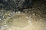
Sinter basin in the back of the cave
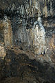
Wall sinter

Sintered surface with small stalactites

Sinter basin in the front area of the cave

Wall sinter


literature
- Stephan Lang: Höhlen in Franken - A hiking guide into the underworld of Hersbrucker Switzerland and the Upper Palatinate Jura . Hans Carl Verlag, Nuremberg 2002, ISBN 3-418-00390-7 , pp. 78-79.
- Friedrich Herrmann: Caves of the Franconian and Hersbrucker Switzerland . 2nd improved edition. Hans Carl Verlag, Nuremberg 1991, ISBN 3-418-00356-7 , pp. 140-141.
Web links
Individual evidence
- ↑ Location of the cave in the Bayern Viewer
- ↑ Annual books for karst and caving, The caves of the karst area A Königstein
- ↑ List of monuments for Vorra (PDF) at the Bavarian State Office for Monument Preservation (PDF; 132 kB)
- ^ Friedrich Herrmann: Caves of the Franconian and Hersbrucker Switzerland , p. 141.
- ↑ Bettina Stoll-Tucker: Post-Ice Age cave use using the example of the upper Pegnitz valley (Northern Franconian Alb). Publishing house Dr. Faustus, Büchenbach 1997, ISBN 3-9803996-6-4 , p. 136.
- ↑ Stephan Lang: Höhlen in Franken - A hiking guide into the underworld of Hersbrucker Switzerland and the Upper Palatinate Jura , p. 79