List of soil monuments in Aschersleben
The list of soil monuments in Aschersleben lists all soil monuments in the city of Aschersleben and its districts. The basis is the publication of the state monument list as of February 25, 2016. The architectural monuments are listed in the list of cultural monuments in Aschersleben .
| Monument ID | Find type | District | designation | Time position | location | Remarks | image |
|---|---|---|---|---|---|---|---|
| 428300372 | Fortification> castle | Klein Schierstedt | Castle wall "Old Castle" | middle Ages | 0.5 km SW of the site | The terrain looks like a plateau over the Wippertal (Geländesporn), which was changed in the northwest by the Güsten – Drohndorf railway line. Some house-like depressions with crumbled stone layers can be seen on the surface to the south. | |
| 428310204 | special stone | Aschersleben | Boulder (special stone?) No OBD | undated | north of the village, right next to the dirt road, probably freshly plowed | Discovered by chance, probably plowed up recently; Directly on a dirt road or on the edge of the field. Presumably quartzite , approx. 90 × 85 cm. | |
| 428300356 | Tomb> burial mound | Aschersleben | Grave mound "Green Hill" | Neolithic | 2.0 km NE of the city | In the case of the main hill, small mounds were created around by animal burrows. In the locality of the hill approx. 1 m long, 0.25 * 0.25 m large stone, possibly a 'menhir'. | |
| 428300355 | special stone | Aschersleben | Menhir "Bacon Side" on a burial mound | Neolithic | E-outskirts, road to Schierstedt | Excavation 1932 ( Paul Grimm ), 1.90 m high menhir (quartzite) on the remains of a burial mound, 1 m is in the ground, about 2.90 m in total. Nails are hammered into the east side. Width: 1.9 m; Thickness: 0.2 m. |

|
| 428300354 | Tomb> burial mound | Aschersleben | "Arnstedter Warte" hill | middle Ages | 2.5 km south of town | Tower not preserved, slight elevation with heavy bushes and contamination, many animal structures. A game feeding manger on the south side. | |
| 428300353 | Tomb> burial mound | Aschersleben | "Staßfurter Warte" hill | middle Ages | 4.5 km northwest of the city | Tower preserved - a steel cable is attached to the tower window, boarding? |

|
| 428300352 | Fortification> castle | Aschersleben | Spornburg "Widdingsburg" | middle Ages | 2 km east of the city, road to Schierstedt | Castle grounds possibly disturbed by new roads. The aerial photo still shows traces of the underground. Clear unevenness in the surface. | |
| 428300351 | Fortification> castle | Aschersleben | Spornburg "Old Castle" | middle Ages | SW outskirts | Curved main wall with a round tower stump. West side approx. 4 m, south-east side curved to the west with a round tower remnant (wall thickness approx. 3 m), integrated within the animal enclosure - main wall coming from the north up to 8 m high. | |
| 428300357 | Tomb> burial mound | Aschersleben | Grave mound "Dreihügelberg" | Neolithic | 2.0 km south of the city | The landscape profile reveals hilly terrain, severely deformed by machine farming. One of the hills shows the destruction of a limestone bank below. There could have been burial mounds here. | |
| 428300380 | Fortification> castle | Westdorf | Valley edge castle "Hodeburg" | middle Ages | 1.2 km southwest of Ort | Castle hill with the outer bailey area to the west over the steep slopes of the Einetal. The south side of the outer bailey area shows the remains of a rampart. To the north, the castle or bailey area is safe due to steep slopes. | |
| 428300358 | Tomb> burial mound | Aschersleben | Burial mound | Neolithic | 1.0 km south of the city, W of the B 180 | on the monument foundation, west side possibly affected by the expansion of Birkenweg (slope deepening), burial mound used to be a monument, granite stairs on top of the hill | |
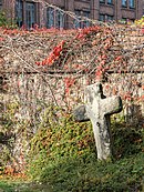
| 428310206 | special stone | Aschersleben | Stone cross | undated | southeast in the village, Lindenstraße 49 (courtyard area) | Sandstone cross with 2 iron rings. Tilted diagonally to the south. |

|
| 428310207 | special stone | Aschersleben | 2 stone crosses | middle Ages | southeast in the village on Mehringer Strasse | Moss-covered and overgrown with lichen. Both sides of a path. Western Cross 1: Red sandstone , broken and held together by iron clips. East Cross 2: probably made of lime sinter . |

|
| 428311116 | special stone | Aschersleben | Menhir "The Blue Goose" | undated | north of the city |

|
|
| 428311114 | Attachment | Aschersleben | Fortification, bastion (city fortification) | middle Ages | in place at the kiln | City fortifications / bastion in the middle of the 15th century - extension of the former remand prison (today city archive, An der Darre 11) |

|
| 428311113 | Tomb> burial mound | Aschersleben | Burial mound | middle Ages | N from the place "blue values" | Diameter 30–40 m, height approx. 1.5 m. | |
| 428311112 | Attachment | Aschersleben | Attachment | middle Ages | in the place "Burggarten" | Below the castle, city fortifications, trenches largely filled. | |
| 428300601 | Fortification> castle | Freckleben | Spurburg | middle Ages | SO outskirts, see also ramparts 428 311 126 | In the center of the complex there is a medieval castle, modified by manor buildings from the 18th to 19th centuries, ramparts in the south and south. O the outer bailey see 428311126! Under protection since October 1st, 1964. Castle association since 2000, residential buildings, renovation work is planned. |

|
| 428300373 | Tomb> burial mound | Klein Schierstedt | "Galgenberg" burial mound | Neolithic | 0.8 km NW of the place | On the hill there is a walled gallows column. Hill approx. 4 m high, diameter 24 m. | |
| 428311127 | Tomb> burial mound | Freckleben | Grave mound - no OBD | undated | south of place | unable to locate, obviously plowed over | |
| 428311126 | Fixing> Wall | Freckleben | Wall systems, Freckleben Castle | undated | T1 site, obviously belongs to Feckleben Castle (Fpl. 3) see: 428300601 | Wall structures belong to Freckleben Castle (Fpl. 3) |

|
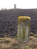
| 428311128 | special stone | Freckleben | Milestone Freckleben | Modern times (from ~ 1500) | at Landstr. K2330 in front of the train tracks | Milestone (1 mile), column, cylindrical, diameter 0.45-0.48 m, height approx. 0.85 m above the ground, heavily weathered |

|
literature
- Small question and answer Olaf Meister (Bündnis 90 / Die Grünen), Prof. Dr. Claudia Dalbert (Bündnis 90 / Die Grünen), Ministry of Culture February 25, 2016 Printed matter 6/3905 (KA 6/9061) List of monuments Saxony-Anhalt
- Erhard Schröter : The protected ground monuments of the Halle district. In: Annual publication for Central German prehistory. Volume 69, 1986, pp. 65-66, 74 ( online ).