|
Serial No.
|
Surname
|
image
|
Year of registration
|
Address / location
|
place
|
ID no.
|
description
|
|
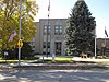
1
|
Allamakee County Court House
|
|
50030000 ♠2003
|
110 Allamakee Street
43 ° 16 ′ 13 ″ N , 91 ° 28 ′ 32 ″ W.43.270277777778 -91.475555555556
|
Waukon
|
03000827
|
the current Courthouse of Allamekee County
|
|
2
|
Allamakee County Courthouse
|

|
49770000 ♠1977
|
107 Allamakee Street
43 ° 16 ′ 15 ″ N , 91 ° 28 ′ 31 ″ W.43.270833333333 -91.475277777778
|
Waukon
|
77000492
|
the second and penultimate courthouse in Allamakee County
|
|
3
|
Effigy Mounds National Monument
|
|
49660000 ♠1966
|
3 miles north of Marquette on Iowa Highway 76
43 ° 5 ′ 33 ″ N , 91 ° 11 ′ 46 ″ W43.0925 -91.196111111111
|
Marquette
|
66000109
|
in large part in Clayton County
|
|
4th
|
Fish Farm Mounds State Preserve
|

|
49880000 ♠1988
|
|
New Albin
|
88001131
|
|
|
5
|
Otto J. Hager House
|

|
49850000 ♠1985
|
402 Allamakee Street
43 ° 16 ′ 22 " N , 91 ° 28 ′ 20" W.43.272777777778 -91.472222222222
|
Waukon
|
85001383
|
|
|
6th
|
Iron Post
|

|
49760000 ♠1976
|
North end of Main Street
43 ° 30 ′ 3 ″ N , 91 ° 16 ′ 59 ″ W.43.500833333333 -91.283055555556
|
New Albin
|
76000732
|
|
|
7th
|
G. Kerndt and Brothers Elevator and Warehouses, No. 11, No. 12 and No. 13
|
|
49790000 ♠1979
|
Front Street
43 ° 21 ′ 33 ″ N , 91 ° 13 ′ 20 ″ W.43.359166666667 -91.222222222222
|
Lansing
|
79000881
|
|
|
8th
|
G. Kerndt & Brothers Office Block
|

|
49820000 ♠1982
|
4th Street and Main Street
43 ° 21 ′ 36 ″ N , 91 ° 13 ′ 9 ″ W.43.36 -91.219166666667
|
Lansing
|
82000402
|
|
|
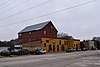
9
|
Lansing Fisheries Building
|

|
49910000 ♠1991
|
between County Highway X-52 and the Mississippi River
43 ° 21 ′ 38 ″ N , 91 ° 12 ′ 48 ″ W43.360555555556 -91.213333333333
|
Lansing
|
91001832
|
|
|
10
|
Lansing Main Street Historic District
|

|
50140000 ♠2014
|
100–401 Main Street, 1 block north and south of Front and 2nd Street, and 190 John Street
43 ° 21 '43 " N , 91 ° 12' 59" W.43.361944444444 -91.216388888889
|
Lansing
|
14000624
|
|
11
|
Lansing Stone School
|

|
49730000 ♠1973
|
Center Street and 5th Street
43 ° 21 ′ 38 ″ N , 91 ° 13 ′ 16 ″ W.43.360555555556 -91.221111111111
|
Lansing
|
73000721
|
|
|
12
|
Fred W. Meier Round Barn
|
|
49860000 ♠1986
|
Off Iowa Highway 9
43 ° 14 ′ 3 ″ N , 91 ° 28 ′ 34 ″ W43.234166666667 -91.476111111111
|
Ludlow
|
86001411
|
|
|
13
|
Monsrud Bridge
|
|
49980000 ♠1998
|
Swebakken Road across Paint Creek
43 ° 13 ′ 9 ″ N , 91 ° 19 ′ 36 ″ W43.219166666667 -91.326666666667
|
Waterville
|
98000771
|
|
|
14th
|
Old Allamakee County Courthouse
|

|
49830000 ♠1983
|
2nd Street
43 ° 21 ′ 35 ″ N , 91 ° 13 ′ 5 ″ W.43.359722222222 -91.218055555556
|
Lansing
|
83000338
|
the first courthouse in Allamakee County
|
|
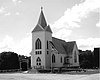
15th
|
Old East Paint Creek Lutheran Church
|

|
49830000 ♠1983
|
North edge of Waterville on County Road A-52
43 ° 15 ′ 52 ″ N , 91 ° 16 ′ 11 ″ W43.264444444444 -91.269722222222
|
Waterville
|
83000339
|
|
|
16
|
Thomas Reburn Polygonal Barn
|
|
49860000 ♠1986
|
Off Iowa Highway 26
43 ° 29 ′ 32 ″ N , 91 ° 18 ′ 11 ″ W43.492222222222 -91.303055555556 4
|
New Albin
|
86001413
|
|
|
17th
|
Red Bridge
|

|
49980000 ♠1998
|
Fuel Hollow Road Bridge over the Yellow River
43 ° 7 ′ 51 ″ N , 91 ° 25 ′ 28 ″ W43.130833333333 -91.424444444444
|
Postville
|
98000773
|
|
|
18th
|
Slinde Mounds State Preserve
|
|
49890000 ♠1989
|
|
Hanover Township
|
88001132
|
|
|
19th
|
Turner Hall
|

|
50,000,000 ♠2000
|
119 East Greene Street
43 ° 5 ′ 5 ″ N , 91 ° 34 ′ 30 ″ W.43.084722222222 -91.575
|
Postville
|
00000921
|
|
|
20th
|
Upper Iowa River Bridge
|

|
49980625 ♠June 25, 1998
|
Mays Prairie Road Bridge over the Upper Iowa River
43 ° 25 ′ 57 ″ N , 91 ° 24 ′ 43 ″ W43.4325 -91.411944444444
|
Dorchester
|
98000772
|
|
|
21st
|
Waterloo Ridge Lutheran Church
|
|
50150721 ♠July 21, 2015
|
169 Dorchester Drive
43 ° 29 ′ 8 ″ N , 91 ° 36 ′ 1 ″ W.43.485555555556 -91.600277777778
|
Surroundings of Dorchester
|
15000435
|
|


