|
|
Surname
|
image
|
Entry date
|
location
|
description
|
|
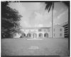
1
|
Algonquin Apartments
|
|
49890104 ♠0January 4, 1989
ID No. 88002985
|
1819-1825 Biscayne Boulevard
25 ° 47 ′ 37 " N , 80 ° 11 ′ 20" W.25.793611 -80.188889
|
Part of the Downtown Miami MRA
|
|
2
|
Atlantic Gas Station
|
more pictures
|
49881229 ♠December 29, 1988
ID No. 88003060
|
668 Northwest 5th Street
25 ° 46 ′ 41 ″ N , 80 ° 12 ′ 22 ″ W.25.778056 -80.206111
|
Part of the Downtown Miami MRA
|
|
3
|
Barracks and Mess Building-US Coast Guard Air Station at Dinner Key
|
more pictures
|
49950810 ♠August 10, 1995
ID no. 95000816
|
2610 Tigertail Avenue
25 ° 43 ′ 55 ″ N , 80 ° 14 ′ 7 ″ W.25.731944 -80.235278
|
|
|
4th
|
Bay Shore Historic District
|
more pictures
|
49921002 ♠0October 2, 1992
ID no. 92001323
|
Approximately bounded by Northeast 55th Street, Biscayne Boulevard, Northeast 60th Street, and Biscayne Bay
25 ° 49 ′ 45.5 ″ N , 80 ° 10 ′ 57.5 ″ W.25.829319 -80.182625
|
|
|
5
|
Brickell mausoleum
|
more pictures
|
49890104 ♠0January 4, 1989
ID No. 88002977
|
501 Brickell Avenue
25 ° 46 ′ 5 ″ N , 80 ° 11 ′ 30 ″ W.25.768056 -80.191667
|
Part of the Downtown Miami MRA
|
|
6th
|
Brickell Point Site
|
more pictures
|
50020205 ♠0February 5, 2002
ID No. 01001534
|
401 Brickell Ave
25 ° 46 ′ 8 " N , 80 ° 11 ′ 21" W.25.768889 -80.189167
|
|
|
7th
|
William Jennings Bryan House
|
|
50120120 ♠January 20, 2012
ID no. 11001029
|
3115 Brickell Ave
25 ° 44 ′ 54.8 " N , 80 ° 12 ′ 21.8" W.25.748569 -80.206053
|
|
|
8th
|
Central Baptist Church
|
more pictures
|
49890104 ♠0January 4, 1989
ID No. 88002988
|
500 Northeast 1st Avenue
25 ° 46 ′ 31 " N , 80 ° 11 ′ 31" W.25.775278 -80.191944
|
Part of the Downtown Miami MRA
|
|
9
|
City National Bank Building
|
more pictures
|
49890104 ♠0January 4, 1989
ID No. 88002975
|
121 Southeast 1st Street
25 ° 46 ′ 30 ″ N , 80 ° 11 ′ 30 ″ W.25.775 -80.191667
|
Part of the Downtown Miami MRA
|
|
10
|
City of Miami Cemetery
|
more pictures
|
49890104 ♠0January 4, 1989
ID No. 88002960
|
1800 Northeast 2nd Avenue
25 ° 47 ′ 38 " N , 80 ° 11 ′ 27" W.25.793889 -80.190833
|
Part of the Downtown Miami MRA
|
|
11
|
Congress Building
|
more pictures
|
49850314 ♠March 14, 1985
ID No. 85000553
|
111 Northeast 2nd Avenue
25 ° 46 ′ 31 ″ N , 80 ° 11 ′ 24 ″ W.25.775278 -80.19
|
|
|
12
|
Dade County Courthouse
|
more pictures
|
49890104 ♠0January 4, 1989
ID No. 88002983
|
73 West Flagler Street
25 ° 46 ′ 27 ″ N , 80 ° 11 ′ 43 ″ W.25.774167 -80.195278
|
Part of the Downtown Miami MRA
|
|
13
|
DA Dorsey House
|
more pictures
|
49890104 ♠0January 4, 1989
ID No. 88002966
|
250 Northwest 9th Street
25 ° 46 ′ 57 " N , 80 ° 11 ′ 56" W.25.7825 -80.198889
|
Part of the Downtown Miami MRA
|
|
14th
|
Marjory Stoneman Douglas House
|
|
50150227 ♠February 27, 2015
ID no. 15000312
|
3744 Stewart Ave.
25 ° 42 ′ 39.6 " N , 80 ° 15 ′ 12.6" W.25.711 -80.2535
|
Home of activist Marjory Stoneman Douglas
|
|
15th
|
Downtown Miami Historic District
|
more pictures
|
50051206 ♠0December 6, 2005
ID no. 05001356
|
Approximately bounded by Miami Ct., 3rd Street, 3rd Avenue and 2nd Street
25 ° 46 ′ 21.2 ″ N , 80 ° 11 ′ 30.6 ″ W25.77255 -80.191839
|
|
|
16
|
Alfred I. DuPont Building
|
more pictures
|
49890104 ♠0January 4, 1989
ID No. 88002984
|
169 East Flagler Street
25 ° 46 ′ 26 ″ N , 80 ° 11 ′ 27 ″ W.25.773889 -80.190833
|
Part of the Downtown Miami MRA
|
|
17th
|
El Jardin
|
more pictures
|
49740830 ♠August 30, 1974
ID No. 74000614
|
3747 Main Highway
25 ° 43 ′ 18 ″ N , 80 ° 14 ′ 54 ″ W.25.721667 -80.248333
|
|
|
18th
|
Fire Station No. 2
|
more pictures
|
49890104 ♠0January 4, 1989
ID No. 88002971
|
1401 North Miami Avenue
25 ° 47'17 " N , 80 ° 11'41" W.25.788056 -80.194722
|
Part of the Downtown Miami MRA
|
|
19th
|
Fire Station No. 4th
|
more pictures
|
49840308 ♠0March 8, 1984
ID No. 84000836
|
1000 South Miami Avenue
25 ° 45 ′ 51 ″ N , 80 ° 11 ′ 36 ″ W.25.764167 -80.193333
|
|
|
20th
|
First Coconut Grove School
|
more pictures
|
49750121 ♠January 21, 1975
ID No. 75000547
|
3429 Devon Road
25 ° 43 ′ 19 ″ N , 80 ° 14 ′ 55 ″ W.25.721944 -80.248611
|
|
|
21st
|
Florida East Coast Railway Locomotive No. 153
|
more pictures
|
49850221 ♠February 21, 1985
ID No. 85000303
|
12400 Southwest 152nd Street
25 ° 37 ′ 15 ″ N , 80 ° 24 ′ 22 ″ W.25.620833 -80.406111
|
|
|
22nd
|
Freedom Tower
|
more pictures
|
49790910 ♠September 10, 1979
ID No. 79000665
|
600 Biscayne Boulevard
25 ° 46 ′ 48 " N , 80 ° 11 ′ 23" W.25.78 -80.189722
|
|
|
23
|
Gesu Church
|
more pictures
|
49740718 ♠July 18, 1974
ID no. 74000617
|
118 Northeast 2nd Street
25 ° 46 ′ 32 " N , 80 ° 11 ′ 31" W.25.775556 -80.191944
|
|
|
24
|
Greater Bethel AME Church
|
more pictures
|
49920417 ♠April 17, 1992
ID No. 88002987
|
245 Northwest 8th Street
25 ° 46 ′ 54 " N , 80 ° 11 ′ 57" W.25.781667 -80.199167
|
Part of the Downtown Miami MRA
|
|
25th
|
I. and E. Greenwald Steam Engine No. 1058
|
more pictures
|
49870312 ♠March 12, 1987
ID No. 87002197
|
3898 Shipping Avenue
25 ° 43 ′ 57 ″ N , 80 ° 15 ′ 27 ″ W.25.7325 -80.2575
|
|
|
26th
|
Hahn Building
|
more pictures
|
49890104 ♠0January 4, 1989
ID No. 88002989
|
140 Northeast 1st Avenue
25 ° 46 ′ 32 " N , 80 ° 11 ′ 32" W.25.775556 -80.192222
|
Part of the Downtown Miami MRA
|
|
27
|
HALF MOON (shipwreck)
|
|
50010531 ♠May 31, 2001
ID no. 01000531
|
near Key Biscayne
25 ° 43 ′ 39 ″ N , 80 ° 8 ′ 4 ″ W.25.7275 -80.134444
|
|
|
28
|
Halissee Hall
|
more pictures
|
49741001 ♠0October 1, 1974
ID no. 74000618
|
1700 Northwest 10th Avenue
25 ° 47 ′ 17 " N , 80 ° 12 ′ 53" W.25.788056 -80.214722
|
|
|
29
|
Huntington Building
|
more pictures
|
49890104 ♠0January 4, 1989
ID No. 88002976
|
168 Southeast 1st Street
25 ° 46 ′ 28 ″ N , 80 ° 11 ′ 27 ″ W.25.774444 -80.190833
|
Part of the Downtown Miami MRA
|
|
30th
|
Ingraham Building
|
more pictures
|
49890104 ♠0January 4, 1989
ID No. 88002958
|
25 Southeast 2nd Avenue
25 ° 46 ′ 23 ″ N , 80 ° 11 ′ 25 ″ W.25.773056 -80.190278
|
Part of the Downtown Miami MRA
|
|
31
|
J&S Building
|
|
49890104 ♠0January 4, 1989
ID No. 88002967
|
221-233 Northwest 9th Street
25 ° 46 ′ 55 " N , 80 ° 11 ′ 53" W.25.781944 -80.198056
|
Part of the Downtown Miami MRA
|
|
32
|
Dr. James M. Jackson Office
|
more pictures
|
49750224 ♠February 24, 1975
ID No. 75000550
|
190 Southeast 12th Terrace
25 ° 45 ′ 39 ″ N , 80 ° 11 ′ 25 ″ W.25.760833 -80.190278
|
|
|
33
|
The Kampong
|
more pictures
|
49840301 ♠0March 1, 1984
ID No. 84000837
|
25 ° 43 ′ 1 ″ N , 80 ° 15 ′ 11 ″ W.25.716944 -80.253056
|
|
|
34
|
Kentucky Home
|
|
49890104 ♠0January 4, 1989
ID No. 88002969
|
1221 and 1227 Northeast 1st Avenue
25 ° 47 ′ 10 " N , 80 ° 11 ′ 31" W.25.786111 -80.191944
|
Part of the Downtown Miami MRA
|
|
35
|
Lummus Park Historic District
|
more pictures
|
50061025 ♠October 25, 2006
ID no. 06000952
|
Approximately bounded by Northwest Second Street, Northwest Third Court, Northwest Fourth Street, and Northwest North River Drive
25 ° 46 ′ 36.7 ″ N , 80 ° 12 ′ 4.2 ″ W25.77685 -80.201164
|
|
|
36
|
Lyric theater
|
more pictures
|
49890104 ♠0January 4, 1989
ID No. 88002965
|
819 Northwest 2nd Avenue
25 ° 46 ′ 55 " N , 80 ° 11 ′ 53" W.25.781944 -80.198056
|
Part of the Downtown Miami MRA
|
|
37
|
Martina Apartments
|
|
49890104 ♠0January 4, 1989
ID No. 88002981
|
1023 South Miami Avenue
25 ° 45 ′ 49 " N , 80 ° 11 ′ 35" W.25.763611 -80.193056
|
Part of the Downtown Miami MRA
|
|
38
|
Meyer-Kiser Building
|
more pictures
|
49890104 ♠0January 4, 1989
ID No. 88002991
|
139 Northeast 1st Building
25 ° 46 ′ 30 ″ N , 80 ° 11 ′ 29 ″ W.25.775 -80.191389
|
Part of the Downtown Miami MRA
|
|
39
|
Miami City Hospital, Building No. 1
|
more pictures
|
49791231 ♠December 31, 1979
ID no. 79000666
|
1611 Northwest 12th Avenue
25 ° 47 ′ 29 " N , 80 ° 12 ′ 45" W.25.791389 -80.2125
|
|
|
40
|
Miami Edison Senior High School
|
more pictures
|
49860605 ♠0June 5, 1986
ID No. 86001212
|
6101 Northwest Second Avenue
25 ° 49 ′ 53 ″ N , 80 ° 12 ′ 0 ″ W.25.831389 -80.2
|
|
|
41
|
Miami Senior High School
|
more pictures
|
49900618 ♠June 18, 1990
ID No. 90000881
|
2450 Southwest First Street
25 ° 46 ′ 17 ″ N , 80 ° 14 ′ 10 ″ W.25.771389 -80.236111
|
|
|
42
|
Miami Women's Club
|
more pictures
|
49741227 ♠December 27, 1974
ID no. 74002257
|
1737 North Bayshore Drive
25 ° 47 ′ 30 ″ N , 80 ° 11 ′ 10 ″ W.25.791667 -80.186111
|
|
|
43
|
Mount Zion Baptist Church
|
more pictures
|
49881229 ♠December 29, 1988
ID No. 88003059
|
301 Northwest 9th Street
25 ° 46 ′ 21 ″ N , 80 ° 11 ′ 57 ″ W.25.7725 -80.199167
|
Part of the Downtown Miami MRA
|
|
44
|
Ralph M. Munroe House
|
more pictures
|
49730411 ♠April 11, 1973
ID No. 73000575
|
3485 Main Highway
25 ° 43 ′ 28 " N , 80 ° 14 ′ 33" W.25.724444 -80.2425
|
|
|
45
|
Old US Post Office and Courthouse
|
more pictures
|
49890104 ♠0January 4, 1989
ID No. 88002962
|
100-118 Northeast 1st Avenue
25 ° 46 '31 " N , 80 ° 11' 33" W.25.775278 -80.1925
|
Part of the Downtown Miami MRA
|
|
46
|
Olympia Theater and Office Building
|
more pictures
|
49840308 ♠0March 8, 1984
ID No. 84000839
|
174 East Flager Street
25 ° 46 ′ 25 ″ N , 80 ° 11 ′ 27 ″ W.25.773611 -80.190833
|
|
|
47
|
Palm Cottage
|
more pictures
|
49890104 ♠0January 4, 1989
ID No. 88002957
|
60 Southeast 4th Street
25 ° 46 ′ 14 " N , 80 ° 11 ′ 33" W.25.770556 -80.1925
|
Part of the Downtown Miami MRA
|
|
48
|
Pan American Seaplane Base and Terminal Building
|
more pictures
|
49750220 ♠February 20, 1975
ID No. 75000548
|
3500 Pan American Drive
25 ° 43 ′ 40 ″ N , 80 ° 14 ′ 3 ″ W.25.727778 -80.234167
|
|
|
49
|
Plymouth Congregational Church
|
more pictures
|
49740723 ♠July 23, 1974
ID no. 74000615
|
3429 Devon Road
25 ° 43 ′ 19 ″ N , 80 ° 14 ′ 18 ″ W.25.721944 -80.238333
|
|
|
50
|
Priscilla Apartments
|
|
49890104 ♠0January 4, 1989
ID No. 88002986
|
318-320 Northeast 19th Street and 1845 Biscayne Boulevard
25 ° 47 ′ 39 " N , 80 ° 11 ′ 20" W.25.794167 -80.188889
|
Part of the Downtown Miami MRA
|
|
51
|
Ransom School "Pagoda"
|
more pictures
|
49730725 ♠July 25, 1973
ID No. 73000572
|
3575 Main Highway
25 ° 43 ′ 21 ″ N , 80 ° 14 ′ 4 ″ W.25.7225 -80.234444
|
|
|
52
|
S&S sandwich shop
|
more pictures
|
49890104 ♠0January 4, 1989
ID No. 88002994
|
1757 Northeast 2nd Street
25 ° 47 ′ 33 " N , 80 ° 11 ′ 28" W.25.7925 -80.191111
|
Part of the Downtown Miami MRA
|
|
53
|
St. John's Baptist Church
|
more pictures
|
49920417 ♠April 17, 1992
ID No. 88002970
|
1328 Northwest 3rd Avenue
25 ° 47 ′ 13 ″ N , 80 ° 12 ′ 1 ″ W.25.786944 -80.200278
|
Part of the Downtown Miami MRA
|
|
54
|
Sears, Roebuck and Company Department Store
|
more pictures
|
49970808 ♠0August 8, 1997
ID No. 84003903
|
1300 Biscayne Boulevard
25 ° 47 ′ 14 " N , 80 ° 11 ′ 24" W.25.787222 -80.19
|
|
|
55
|
Security building
|
more pictures
|
49890104 ♠0January 4, 1989
ID No. 88002990
|
117 Northeast 1st Avenue
25 ° 46 ′ 31 ″ N , 80 ° 11 ′ 31 ″ W.25.775278 -80.191944
|
Part of the Downtown Miami MRA
|
|
56
|
Shoreland Arcade
|
more pictures
|
49890104 ♠0January 4, 1989
ID No. 88002992
|
120 Northeast 1st Street
25 ° 46 ′ 28 ″ N , 80 ° 11 ′ 29 ″ W.25.774444 -80.191389
|
Part of the Downtown Miami MRA
|
|
57
|
South River Drive Historic District
|
more pictures
|
49870810 ♠August 10, 1987
ID No. 87000671
|
428 and 438 Southwest First Street, 437 Southwest Second Street, and 104, 109 and 118 Southwest South River Drive
25 ° 46 ′ 20 ″ N , 80 ° 12 ′ 6 ″ W.25.772222 -80.201667
|
|
|
58
|
Southside School
|
more pictures
|
49890104 ♠0January 4, 1989
ID No. 88002980
|
45 Southwest 13th Street
25 ° 45 ′ 41 ″ N , 80 ° 11 ′ 58 ″ W.25.761389 -80.199444
|
Part of the Downtown Miami MRA
|
|
59
|
Trapp Homestead
|
more pictures
|
49941110 ♠November 10, 1994
ID No. 94001279
|
2521 South Bayshore Drive
25 ° 44 ′ 1 ″ N , 80 ° 14 ′ 17 ″ W.25.733611 -80.238056
|
|
|
60
|
Trinity Episcopal Cathedral
|
more pictures
|
49801010 ♠October 10, 1980
ID no. 80000945
|
464 Northeast 16th Street
25 ° 47 ′ 24 ″ N , 80 ° 11 ′ 12 ″ W.25.79 -80.186667
|
|
|
61
|
US Car No. 1
|
more pictures
|
49770824 ♠August 24, 1977
ID No. 77000401
|
3398 Southwest 9th Avenue
25 ° 37 ′ 1.6 " N , 80 ° 24 ′ 2.3" W.25.617117 -80.400647
|
|
|
62
|
US Coast Guard Air Station at Dinner Key
|
more pictures
|
50021219 ♠December 19, 2002
ID no. 02001535
|
2600 South Bayshore Drive
25 ° 43 ′ 51 ″ N , 80 ° 14 ′ 4 ″ W.25.730833 -80.234444
|
|
|
63
|
US Post Office and Courthouse
|
more pictures
|
49831014 ♠October 14, 1983
ID no. 83003518
|
300 Northeast 1st Avenue
25 ° 46 ′ 38 " N , 80 ° 11 ′ 34" W.25.777222 -80.192778
|
|
|
64
|
Vagabond Motel
|
|
50141229 ♠December 29, 2014
ID no. 14001086
|
7301 Biscayne Blvd.
25 ° 50 '34.4 " N , 80 ° 11' 2.2" W.25.842891 -80.183957
|
|
|
65
|
Venetian Causeway
|
more pictures
|
49890713 ♠July 13, 1989
ID No. 89000852
|
Northeast 15th Street and Dade Boulevard
25 ° 47 ′ 21 ″ N , 80 ° 11 ′ 21 ″ W25.789167 -80.189167
|
leads to Miami Beach
|
|
66
|
Virginia Key Beach Park
|
more pictures
|
50020628 ♠June 28, 2002
ID no. 02000681
|
East of Biscayne Bay and north of Rickenbacker Causeway
25 ° 44 ′ 2 ″ N , 80 ° 9 ′ 43 ″ W25.733889 -80.161944
|
|
|
67
|
Vizcaya
|
more pictures
|
49700929 ♠September 29, 1970
ID No. 70000181
|
3251 South Miami Avenue; bounded approximately by the South Dixie Highway, Southwest 32nd Road and South Miami Avenue at
25 ° 44 ′ 37 ″ N , 80 ° 12 ′ 37 ″ W25.743611 -80.210278
|
Converted to a National Historic Landmark on April 19, 1994. National Register Information System . In: National Register of Historic Places . National Park Service .
|
|
68
|
Walgreen Drug Store
|
more pictures
|
49890104 ♠0January 4, 1989
ID No. 88002982
|
200 East Flagler Street
25 ° 46 ′ 29 ″ N , 80 ° 11 ′ 25 ″ W.25.774722 -80.190278
|
Part of the Downtown Miami MRA
|
|
69
|
JW Warner House
|
more pictures
|
49830601 ♠0June 1, 1983
ID no. 83001419
|
111 Southwest 5th Avenue
25 ° 46 ′ 24 " N , 80 ° 12 ′ 10" W.25.773333 -80.202778
|
|
|
70
|
Women's Club of Coconut Grove
|
more pictures
|
49750326 ♠March 26, 1975
ID No. 75000549
|
2985 South Bayshore Drive
25 ° 43 ′ 37 ″ N , 80 ° 14 ′ 24 ″ W.25.726944 -80.24
|
|