List of listed objects in Enzersfeld in the Weinviertel
The list of listed objects in Enzersfeld in the Weinviertel contains the 10 listed , immovable objects of the Lower Austrian market town of Enzersfeld .
Monuments
| photo | monument | Location | description | Metadata |
|---|---|---|---|---|

|
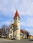
Catholic Parish Church of the Birth of Mary ObjectID : 19538 |
Kirchenplatz KG location : Enzersfeld |
The hall church, which is romanticized on the outside and secessionist on the inside, with a corner tower and offsides , was built in 1908/09. |
ObjectID : 19538 Status: § 2a Status of the BDA list: 2020-02-29 Name: Catholic Parish Church Mariae Birth GstNr .: .27 Parish Church Mariae Birth, Enzersfeld in the Weinviertel |

|
Find zone Langes Enzersbrunnfeld ObjectID : 1772 |
Langes Enzersbrunnfeld KG location : Enzersfeld |
A total of 344 archaeological findings came to light in the La Tène period / Roman period settlement. In addition to some Neolithic litter finds, a few Urnfield pits were discovered. The focus was on a Celtic-Germanic settlement, three small, late medieval graves of unknown function, a modern field and a rifle position from World War II were documented. |
ObjectID: 1772 Status: Notification Status of the BDA list: 2020-02-29 Name: Find zone Langes Enzersbrunnfeld GstNr .: 2819; 2820; 2821; 2822; 2823; 2824; 2825; 2826; 2827; 2828; 2829; 2830; 2831; 2832; 2833; 2834/1; 2834/2; 2835; 2836; 2837; 2838; 2839; 2840/1; 2840/2; 2841; 2842; 2843; 2844/1; 2844/2; 2845; 2848; 2851/1; 2851/2 |

|
Crucifixion Group ObjectID : 19539 |
Kirchenplatz KG location : Enzersfeld |
The crucifixion group with the assistant figures of Saint Mary, Mary Magdalene and John the Evangelist was built around 1720. |
ObjectID : 19539 Status: § 2a Status of the BDA list: 2020-02-29 Name: Kreuzigungsgruppe GstNr .: 2519/1 Kreuzigungsgruppe (Enzersfeld) |

|
Plague / Trinity Column ObjectID: 19543 |
Hauptstrasse 26 KG location : Enzersfeld |
1st half of the 19th century. |
ObjectID: 19543 Status: § 2a Status of the BDA list: 2020-02-29 Name: Pest- / Dreifaltigkeitssäule GstNr .: 2519/2 |

|
Shrine Object ID: 19544 |
Kasinoplatz location KG: Enzersfeld |
Niche shrine with cuboid column, copper roof and iron cross. |
ObjectID : 19544 Status: § 2a Status of the BDA list: 2020-02-29 Name: Bildstock GstNr .: 2519/4 |

|
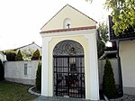
Corridor / path chapel St. Johannes Nepomuk ObjectID : 19542 |
opposite Manhartsbrunnerstraße 7 KG location : Enzersfeld |
The building with a curved gable and segmental arch opening around the square vault was built in the middle of the 19th century. The statue of St. Nepomuk is labeled 1856. |
ObjectID : 19542 Status: § 2a Status of the BDA list: 2020-02-29 Name: Flur- / Wegkapelle hl. Johannes Nepomuk GstNr .: 2505/1 John of Nepomuk chapel, Enzersfeld |

|
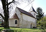
Catholic branch church hl. Maria Magdalena ObjectID : 19547 |
Am Kirchberg 2 location KG: Königsbrunn |
Mostly reconstructed Romanesque hall church from the end of the 12th and beginning of the 13th century. with west tower. After the war-related damage in 1945, it was rebuilt from 1953 to 1956. |
ObjectID : 19547 Status: § 2a Status of the BDA list: 2020-02-29 Name: Kath. Filialkirche hl. Maria Magdalena GstNr .: .1 Koenigsbrunn-Filialkirche |

|
Find zone Langes Enzersbrunnfeld ObjectID : 1773 |
Langes Enzersbrunnfeld KG location : Königsbrunn |
A total of 344 archaeological findings came to light. In addition to some Neolithic litter finds, a few Urnfield pits were discovered. The focus was on a Celtic-Germanic settlement, three small, late medieval graves of unknown function, a modern field and a rifle position from World War II were documented. |
ObjectID: 1773 Status: Notification Status of the BDA list: 2020-02-29 Name: Find zone Langes Enzersbrunnfeld GstNr .: 1177; 1178; 1179; 1180; 1181; 1182; 1183; 1189; 1190; 1191; 1192; 1193; 1194; 1195; 1196; 1197; 1198; 1199; 1200/1; 1200/2; 1201; 1202; 1203; 1204; 1205; 1206; 1207; 1208 |

|
Wayside shrine ObjectID: 19545 |
Stettener Straße KG location : Königsbrunn |
Eight-sided pillar with square top from 1711. |
ObjectID: 19545 Status: § 2a Status of the BDA list: 2020-02-29 Name: Bildstock GstNr .: 1096/2 |

|
Corridor / path chapel St. Johannes Nepomuk ObjectID : 19549 |
Hagenbrunner Straße KG location : Königsbrunn |
Gable structure, closed on three sides, built in 1771. In the arched, open conical interior is the statue of St. Johannes Nepomuk, inscribed 1745. |
ObjectID : 19549 Status: § 2a Status of the BDA list: 2020-02-29 Name: Flur- / Wegkapelle hl. Johannes Nepomuk GstNr .: .102 |
Web links
Commons : Listed objects in Enzersfeld in the Weinviertel - collection of images, videos and audio files
Individual evidence
- ↑ a b Lower Austria - immovable and archaeological monuments under monument protection. (PDF), ( CSV ). Federal Monuments Office , as of February 14, 2020.
- ↑ a b c d e f g Dehio Niederösterreich - North of the Danube, Vienna 1990, ISBN 3-7031-0652-2
- ↑ Bernhard Hebert, Nikolaus Hofer: Annual Report on Archaeological Monument Preservation 2009. Federal Monuments Office , 2009, archived from the original on July 1, 2016 ; accessed on October 28, 2017 .
- ^ A b Find reports from Austria 48th Bundesdenkmalamt , 2009, p. 415 , archived from the original on April 24, 2016 ; accessed on October 28, 2017 .
- ↑ § 2a Monument Protection Act in the legal information system of the Republic of Austria .