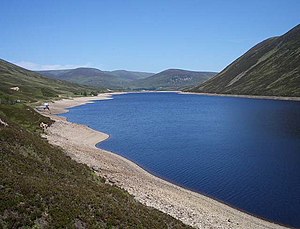
Loch Garry (Perth and Kinross)
| Loch Garry | ||
|---|---|---|

|
||
| Loch Garry still seen north | ||
| Geographical location | Grampian Mountains , Perth and Kinross , Scotland | |
| Tributaries | Allt Shallainn | |
| Drain | Garry → Tummel → Tay → Firth of Tay → North Sea | |
| Islands | no | |
| Data | ||
| Coordinates | 56 ° 48 '15 " N , 4 ° 14' 52" W | |
|
|
||
| Altitude above sea level | 397 m ASL | |
| length | 4.5 km | |
| width | 500 m | |
Loch Garry is a dammed freshwater lake in the Scottish Highlands . It is located in the Grampian Mountains in the Unitary Authority Perth and Kinross . The lake has the typical elongated shape of a lake created by glaciers in the Ice Age . Loch Garry is up to 4.5 km long, but only a maximum of 500 m wide.
The lake is fed with water at its southern end by the Allt Shallainn . Loch Garry drains to the north into the River Garry , of which it is the source. Loch Garry is part of the Tummel Hydro-Electric Power Scheme . The outflow of the lake is regulated by a small dam. With the help of the dam, it is possible to control the amount of water in the Garry River and ultimately to ensure a constant water supply for the hydroelectric power station located on Loch Faskally . Accordingly, the water level of Loch Garry fluctuates greatly.
The banks of Loch Garry are completely uninhabited. There are also no larger settlements in the immediate vicinity. The lake is only accessed by an unpaved road on its western bank. All other sections of the bank cannot be reached by car.

