Loch of Aboyne
| Loch of Aboyne | ||
|---|---|---|

|
||
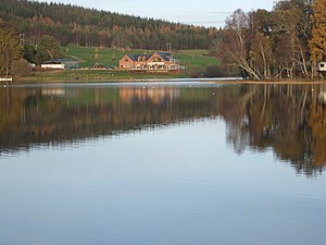
| Loch of Aboyne photographed from the south | ||
| Geographical location | Aberdeenshire , Scotland | |
| Drain | → Tarland Burn → Dee | |
| Location close to the shore | Aboyne | |
| Data | ||
| Coordinates | 57 ° 5 '15 " N , 2 ° 45' 25" W | |
|
|
||
| Altitude above sea level | 132.5 m ASL | |
| surface | 12.2 ha | |
| length | 500 m | |
| width | 200 m | |
| volume | 280,000 m³ | |
| Maximum depth | 3.4 m | |
| Middle deep | 1.8 m | |
Loch of Aboyne is an artificial freshwater lake in Aberdeenshire , Scotland . It is located about two kilometers northeast of the eponymous town of Aboyne . The lake was dammed by an earth dam around 1830 and originally served as a water reservoir for a nearby water mill .
The lake is extensively developed for tourism . The grounds of the Aboyne Golf Club border the south shore of the lake. There is a hotel with a spa right on the north bank . In front of the east bank is a peninsula in the lake that is used entirely as a campsite .
Nevertheless, Loch of Aboyne has a fairly extensive flora and fauna . The bank section between the hotel and the campsite is heavily overgrown with reed plants and is home to a large variety of leeches and mud snails . Numerous migratory birds such as the wigeon , the goosander and the roach use the lake as a stopover on their way north or south.
Loch of Aboyne is also a relatively fish-rich fishing area, where you can catch perch , pike and eel , among others .
