
Loup (river)
| Loup | ||
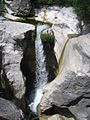
 The entrance to the Loup Gorge at Le Bar-sur-Loup |
||
| Data | ||
| Water code | FR : Y5610500 | |
| location | France , Provence-Alpes-Cote d'Azur region | |
| River system | Loup | |
| source | in the parish of Andon, 43 ° 45 ′ 44 ″ N , 6 ° 45 ′ 55 ″ E |
|
| Source height | approx. 1310 m | |
| muzzle | on the municipal boundary of Cagnes-sur-Mer and Villeneuve-Loubet in the Mediterranean Coordinates: 43 ° 38 ′ 31 ″ N , 7 ° 8 ′ 44 ″ E, 43 ° 38 ′ 31 ″ N , 7 ° 8 ′ 44 ″ E |
|
| Mouth height | 0 m | |
| Height difference | approx. 1310 m | |
| Bottom slope | approx. 27 ‰ | |
| length | 49 km | |
The Loup is a river in southern France that runs in the Alpes-Maritimes department in the Provence-Alpes-Côte d'Azur region . Its source brook Vallon de l'Audibergue has its source in the hamlet of La Moulière in the municipality of Andon . The river drains through the Maritime Alps first to the east, later to the south-east and after 49 kilometers flows into the Mediterranean Sea at the municipal boundary of Cagnes-sur-Mer and Villeneuve-Loubet .
Places on the river
Attractions
- Saut du Loup and Cascade de Courmes waterfalls
- Canyon Gorges du Loup , a known beyond France climbing area

You sauté Loup
You sauté Loup

You sauté Loup


See also
- List of French Mediterranean tributaries and their tributaries, from 36 km in length, sorted geographically
Web links
Commons : Loup - collection of pictures, videos and audio files
Individual evidence
- ↑ Source geoportail.gouv.fr
- ↑ estuary geoportail.gouv.fr
- ↑ a b The information on the river length is based on the information about the Loup at SANDRE (French), accessed on November 30, 2012, rounded to full kilometers.