Lovill Bluff
| Lovill Bluff | ||
|---|---|---|
| location | Siple Island ( West Antarctica ) | |
|
|
||
| Coordinates | 73 ° 22 ′ S , 126 ° 54 ′ W | |
|
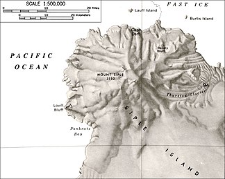
Map of the northwestern part of Siple Island with Lovill Bluff (left) |
||
The Lovill Bluff is a cliff of rock and ice on the western end of Siple Island before Bakutis Coast of the West Antarctic Marie Byrd lands . It rises 22 km southwest of the summit of Mount Siple and marks the north side of the entrance to Pankratz Bay .
The United States Geological Survey mapped it using the United States Navy's own surveys and aerial photographs from 1959 to 1965. The Advisory Committee on Antarctic Names named it in 1966 after James E. Lovill, meteorologist for the United States Antarctic Research Program on the Byrd- Station in 1965.
Web links
- Lovill Bluff in the Geographic Names Information System of the United States Geological Survey (English)
- Lovill Bluff on geographic.org (English)

