Luena (river, Zambia)
|
Luena Lwena |
||
|
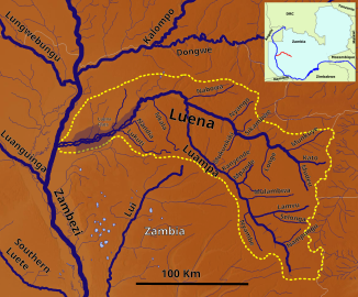
The catchment area of the Luena |
||
| Data | ||
| location |
|
|
| River system | Zambezi | |
| Drain over | Zambezi → Strait of Mozambique | |
| source | On the border with Central Province 15 ° 8 ′ 17 ″ S , 25 ° 20 ′ 46 ″ E |
|
| Source height | 1189 m | |
| muzzle | In the Zambezi Coordinates: 14 ° 49 ′ 12 ″ S , 23 ° 1 ′ 34 ″ E 14 ° 49 ′ 12 ″ S , 23 ° 1 ′ 34 ″ E |
|
| Mouth height | 1026 m | |
| Height difference | 163 m | |
| Bottom slope | 0.47 ‰ | |
| length | over 350 km | |
| Left tributaries | Luampa | |
| Small towns | Kaoma | |
Luena , also Lwena , is a river in the Western Province of Zambia .
course
The Luena rises on the western border of the Kafue National Park . It flows in a wide northern arc 350 kilometers to the west and flows into the Zambezi .
geography
The bank regions of the river in its upper and middle reaches are comparatively densely populated and almost entirely surrounded by fields. The road from Lusaka to Mongu leads only a little to the north, almost parallel to the meandering river course, which ensures supply and market access to this area.
Individual evidence
- ↑ Soviet General Staff Map , accessed via http://loadmap.net/

