
Lukla
| Lukla | |||
|---|---|---|---|
|
|||
| Coordinates | 27 ° 41 ′ N , 86 ° 44 ′ E | ||
| Basic data | |||
| Country | Nepal | ||
| Province No. 1 | |||
| ISO 3166-2 | NP-P1 | ||
| District | Solukhumbu | ||
| height | 2860 m | ||
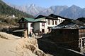
 Lukla, main street
|
|||

Lukla is a place in the Khumbu region ( VDC Chaurikharka , Solukhumbu district ) in Nepal , at an altitude of 2860 m above sea level above the Dudhkoshi river valley.
The name of the place derives from a former sheep pen, where the Tenzing Hillary Airport is located today .
The airport is known as one of the most dangerous airfields in the world. The runway is very short, uphill and bordered at one end by a gorge and at the other by a mountain wall. Therefore take-off and landing are associated with a very high risk.
Lukla is the only access to the Khumbu region and the Sagarmatha National Park and usually the starting point for the Mount Everest Trek , aside from a few low-traffic passes in the high mountains . The place offers a range of accommodations and shops where you can buy missing equipment. However, the Namche Bazar, about ten leagues further north, offers better supply options .
photos

Approach to Lukla

View of Lukla from the airfield

Lukla, main street

Place and airfield
Lukla, entrance to the village
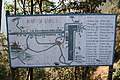
Map of Lukla


