
Chaurikharka
| Chaurikharka चौरीखर्क |
|||
|---|---|---|---|
|
|||
| Coordinates | 27 ° 42 ' N , 86 ° 43' E | ||
| Basic data | |||
| Country | Nepal | ||
| Province No. 1 | |||
| Zone | Sagarmatha | ||
| ISO 3166-2 | NP-P1 | ||
| District | Solukhumbu | ||
| height | 2650 m | ||
| Residents | 3709 (2011) | ||
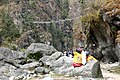
 River Dudhkoshi at Ghat (picture from 1997)
|
|||

Chaurikharka ( Nepali चौरीखर्क ; also Chauri Kharka ) is a village and a Village Development Committee (VDC) in the Solukhumbu district of the Sagarmatha administrative zone in eastern Nepal .
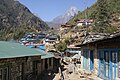
The VDC Chaurikharka is located in the High Himalayas , 35 km south-southwest of Mount Everest . The mountains Kongde Ri in the west and Kangtega and Kusum Kanguru in the east lie within or on the border of Chaurikharka. The Dudhkoshi River cuts the VDC area to the south. Most of the villages are above the river valley. The airfield near Lukla is an important gateway for tourists to the Mount Everest area. The Mount Everest Trek leads along the Dudhkoshi past the villages of Chaurikharka.
Residents
The VDC Chaurikharka had 3709 inhabitants (1872 of them male) in 968 households in the 2011 census.
Villages and Hamlets
Chaurikharka consists of several villages and hamlets . The most important are:
- Benkar ( 2750 m ⊙ )
- Chaurikharka ( 2750 m ⊙ )
- Chheplung ( 2670 m ⊙ )
- Ghat ( 2820 m ⊙ )
- Lukla ( 2850 m ⊙ )
- Manjo ( 2820 m ⊙ )
- Nachipang ( 2700 m ⊙ )
- Phakding ( 2620 m ⊙ )
- Sano Gemela ( 3040 m ⊙ )
- Sengma ( 2685 m ⊙ )
- Surke ( 2250 m ⊙ )
- Thulo Gemela ( 3060 m ⊙ )
- Toktok ( 2700 m ⊙ )
![]() Map with all coordinates of the section Villages and Hamlets : OSM
Map with all coordinates of the section Villages and Hamlets : OSM
gallery
- Chaurikharka - from Lukla to Namche

From Lukla to Chheplung

Chopping

Chhuthawa

Nyambua Thyang
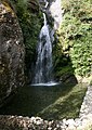
Toktok waterfall

Benkar
Manjo

Tawa

Jorsale
Larja Bridge


Web links
Individual evidence
- ↑ National Population and Housing Census 2011 (PDF) Central Bureau of Statistics. Archived from the original on July 31, 2013.
- ^ District: Solukhumbu. List of Settlements (PDF) In: Index of Geographical names of Nepal . National Geographic Information Infrastructure Program. www.ngiip.gov.np. Archived from the original on January 9, 2016. Info: The archive link was inserted automatically and has not yet been checked. Please check the original and archive link according to the instructions and then remove this notice. Retrieved September 5, 2015.