Lukpe Lawo
| Lukpe Lawo - Snow Lake | ||
|---|---|---|
|
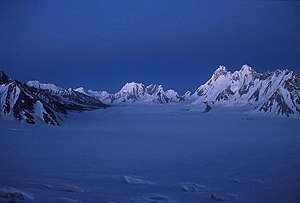
in the foreground the Lukpe Lawo, in the background the Sim Gang |
||
| location | Gilgit-Baltistan ( Pakistan ) | |
| Mountains | Karakoram | |
| length | 16 km | |
| Exposure | south | |
| Coordinates | 36 ° 0 ′ N , 75 ° 35 ′ E | |
|
|
||
| drainage | Biafo glacier | |
|
Biafo glacier below with Simgang glacier bending to the right and Lukpe Lawo leading to the top left |
||
The Lukpe Lawo or Snow Lake ( "Snow Lake") is part of a high-altitude glacial basins in Karakorum in Gilgit-Baltistan , the former Northern Areas of Pakistan .
geography
The Snow Lake is at over 4500 m above sea level and is about 16 km long. Together with the similarly long Simgang Glacier it forms the Nährregion of Biafogletschers . While Eric Shipton differentiated between Snow Lake in the north and Simgang Glacier in the east on the map created after his expedition in this area, other authors use Snow Lake to refer to the entire basin of Simgang Glacier and Lupke Lawo (the actual Snow Lake).
Lukpe Lawo and Simgang Glacier together cover an area of around 300 km 2 .
On the west side of the glacier basin is the Hispar pass , which connects the Biafo- with the Hispar glacier . The two glaciers extend from the Hispar Pass in different directions and together with a length of 100 km form one of the largest glacier traverses on earth outside the polar regions . Other saddles in the framing mountain ranges are the (Eastern) Khurdopin Pass , which connects the Lukpe Lawo with the Khurdoping Glacier in the north, and the Virjerab Pass , which enables a transition to the Virjerab Glacier . Virjerab and Khurdoping glaciers flow north to the Shimshal valley . The Lukpe La pass is not located on Lukpe Lawo, but on the Simgang glacier and connects it to the north with the Braldu glacier . The Sim La connects the Simgang Glacier with the Choktoi Glacier , the Skam La with the Nobande Sobande Glacier . The Choktoi and Nobande Sobande glaciers both flow to the southeast and merge to form the Panmah glacier .
First explorers
The members of the Karakoram expedition led by William Martin Conway were the first foreigners to visit Snow Lake in 1892. Conway, a British politician and mountaineer, gave it his name and described Snow Lake as “beyond all comparison the finest view of mountains it has ever” been my lot to behold, nor do I believe the world can hold a finer. ”Snow Lake is difficult to reach and only 200 people come to this place a year. In 1908 the couple William Hunter Workman and Fanny Bullock Workman reached him and they speculated, since they miscalculated the size of the glacier at 700 km², whether the Snow Lake was as thick as the ice caps of the polar regions, of which the glaciers in all Directions flow. This assumption was corrected in 1939 by the British Himalayan explorer Eric Shipton to 45 km². In the 1940s, Snow Lake was renamed Lukpe Lawo , a translation into the language of the Balti .
Web links
- Map and photos at himalaya-info.org
Individual evidence
- ↑ Eric Shipton: Blank on the Map (1938) . In: The Six Mountain Travel Books . New edition of the version from 1985 edition. Baton Wicks, London 2010, ISBN 978-1-898573-81-4 , pp. 158 (English).
- ^ A b c M. P. Searle: Geology and Tectonics of the Karakoram Mountains. Chichester 1991, pp. 261-264.
- ^ William Martin Conway: Climbing and Exploration in the Karakoram-Himalayas. London 1894, p. 377 ( archive.org , accessed November 28, 2012).
- ^ David Noland: Pakistan: Snow Lake. In: Outside Online. Archived from the original on December 2, 2009 ; accessed on November 28, 2012 (English).
- ↑ blankonthemap.free.fr Information on blankonthemap.free.fr, accessed on January 28, 2012.
- ^ Peter Mott: 1939 Karakoram Expedition. In: Himalayan Journal. 13, 1946, accessed January 28, 2012.


