Lypovetser lake
|
Lypowezer See lake eye |
||
|---|---|---|

|
||
| Geographical location |
Zakarpattia Oblast , Ukraine |
|
| Data | ||
| Coordinates | 48 ° 17 '39 " N , 23 ° 17' 22" E | |
|
|
||
| Altitude above sea level | 526 m | |
| surface | 0.18-0.3 ha | |
| Maximum depth | 5.7 m | |
|
particularities |
||
The Lypowezer lake (Ukrainian Липовецьке озеро / Lypowezke osero , Russian Липовецкое озеро Lipowezkoje osero ) is a crater lake in the Ukrainian Forest Carpathians .
Lake Lypovets , also known as Lake Eye ( Морське око ), was created in the crater of an extinct volcano and is a hydrological natural monument of volcanism in the Carpathian Mountains.
The round lake has an area of 0.18-0.3 hectares and a depth of 5.7 m. The lake has no tributaries. It is fed by deep water from great depths. It never dries out and never freezes over.
Geographical location
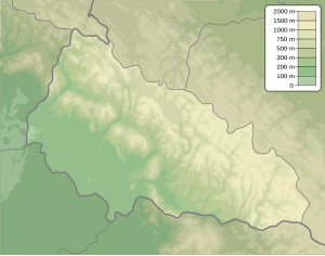
The lake is located in Rajon Khust of Zakarpattia Oblast , 15 kilometers north of the city of Chust the village Lypcha to 526 m height.
Web links
- See the lake on zakarpattyachko.com.ua (Ukrainian)
- See the lake on ua.igotoworld.com (Ukrainian)
Individual evidence
- ↑ Entry on Lake Lypovetske in the Encyclopedia of Modern Ukraine ; accessed on May 1, 2017 (Ukrainian)
