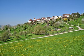
Mönchberg (Herrenberg)
|
Mönchberg
City of Herrenberg
|
|
|---|---|
| Coordinates: 48 ° 34 ′ 59 " N , 8 ° 54 ′ 46" E | |
| Height : | 420–500 m above sea level NN |
| Residents : | 1135 (Nov. 30, 2018) |
| Incorporation : | 1st December 1971 |
| Postal code : | 71083 |
| Area code : | 07032 |
The former municipality of Mönchberg has been one of the eight districts of Herrenberg today due to the municipal reform in Baden-Württemberg since 1971 .
geography
Mönchberg is located in the Korngäu , four kilometers from Herrenberg , near the A 81 Stuttgart - Singen motorway . The place is on the edge of the Keuperstufen of the Schönbuch .
history
The place was created in the 12th and 13th centuries. Around 1125, the clearing of the Schönbuch slope for viticulture began , shortly afterwards a settlement was established on the so-called "Mönchberg", from which the Benedictine monastery of St. Michael was created.
It was not until later that, as in Kayh, viticulture was replaced by fruit growing . In terms of fruit cultivation, the place is located in one of the largest contiguous orchards in Europe.
Mönchberg was an independent municipality since 1833 until it was incorporated into Herrenberg on December 1, 1971.
Individual evidence
- ↑ Streuobstparadies.de - location and size. Website of the Schwäbisches Streuobstparadies eV association. Accessed on November 22, 2015.
- ^ Federal Statistical Office (ed.): Historical municipality directory for the Federal Republic of Germany. Name, border and key number changes in municipalities, counties and administrative districts from May 27, 1970 to December 31, 1982 . W. Kohlhammer, Stuttgart / Mainz 1983, ISBN 3-17-003263-1 , p. 447 .


