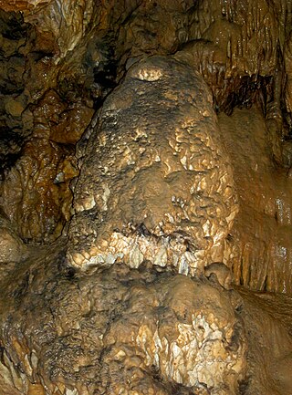
Mühlheim rock cave
| Mühlheim rock cave
|
||
|---|---|---|
|
Mühlheimer cave |
||
| Location: | Swabian Alb , Baden-Wuerttemberg , Mühlheim an der Donau | |
| Height : | 780 m above sea level NN | |
|
Geographic location: |
48 ° 2 '19.6 " N , 8 ° 54' 0.1" E | |
|
|
||
| Cadastral number: | 7919/19 | |
| Type: | Stalactite cave | |
| Overall length: | 134 m | |
The Mühlheimer Felsenhöhle is located in Mühlheim an der Donau . The stalactite cave was first opened up by the Swabian Alb Association in 1912, then again in 1977. For historical reasons, the entrance to the cave is open in the rock dump (hence the name rock cave), so the cave was not discovered by a landslide or by accident.
The rock cave does not correspond to a show cave in the traditional sense . The cave is in its natural state and secured in such a way that the visitor remains accident-free during a normal inspection.
The cave can be visited free of charge every year on Ascension Day , if the Swabian Alb Association is hosting the cave festival at the same time . At other times, only group visits are possible, as the entrance to the cave is closed to protect against vandalism. In the period from the end of October to mid-March, the cave is also not available for group tours, as bats are in hibernation during this time.
General information about the cave
The temperature in the cave is 5–7 ° C all year round, it is 134 meters long.
Right behind the entrance is a 3.5 meter high iron ladder. In about the middle of the cave you pass a 25 meter deep crevice on a concrete footbridge (with iron railing). At the end of the rock cave, an 8.5 meter high ladder with a handrail leads to the so-called cave basin. In this cauldron you can see a magnificent fossil under the ladder, at the foot of which there is a small spring with a sinter basin . A year with the digits 1813 proves that the cave was visited before it was opened in 1912.
The ascent to the cave begins at the Mühlheimer Friedhof in the old town. The slightly steeply rising marked path in the Buchhalde-Oberes Donautal nature reserve takes you to the rock cave in around 20 minutes. Geologically, the cave is located in the limestone layers of the White Jura delta and epsilon.
literature
- Hans Binder , Herbert Jantschke: Cave guide Swabian Alb. Caves - springs - waterfalls . 7th completely revised edition. DRW-Verlag, Leinfelden-Echterdingen 2003, ISBN 3-87181-485-7 , p. 217 .
Web links
Individual evidence
- ↑ Official map. State Institute for the Environment, Measurements and Nature Conservation Baden-Württemberg, archived from the original on July 13, 2012 ; Retrieved February 27, 2012 .
- ↑ Mühlheimer Höhle: Information on the geographic object. State Office for Geology, Raw Materials and Mining Baden-Württemberg, accessed on November 30, 2017 .

