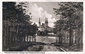
Munich Reuther Forest
The Munich Reuther forest is a dense forest on a ridge between Mount Výhledy (656 m) and the town of Waldsassen in the administrative district of Upper Palatinate belonging southern Kohlwald in Tirschenreuth .
Until July 1997, the Münchenreuther Wald was one of the community-free areas in the Tirschenreuth district.
geography
The ridge consists of several elevations around the Dietzenberg (626 m). The Trinity Church Kappl is located between Dietzenberg and Glasberg (628 m), near the town of Münchenreuth . Other prominent elevations are Gossenbühl (616 m), Haselrangen (602 m), Kappl (600 m), Wirtsrangen (578 m) and Platte (577 m). The state road St 2178 runs through the forest area and connects Schirnding via Münchenreuth with Waldsassen, the district road TIR 15 connects the town of Münchenreuth with the state road St 2175 from Konnersreuth to Waldsassen.
Tourist development
Kappl can be reached on foot from Waldsassen via the Rosary Station Trail (hiking trail no.5), which is unique in Europe . The 15 baroque prayer columns that line the path were erected in 1698 under Abbot Albert Hausner .
history
In the past, the forest served as a source of raw materials for the towns of Waldsassen (with monastery ) and Eger and for the former coal piles of iron smelting in Arzberg .
cards
- Digital location map 1: 10,000 Bavaria-North from the State Office for Surveying and Geoinformation Bavaria 2007
- Fritsch hiking map 1: 50,000 Fichtelgebirge Nature Park, 17th edition
literature
- The Tirschenreuth district , Munich 1967
- Dietmar Herrmann, Helmut Süssmann: Fichtel Mountains, Bavarian Vogtland, Steinwald, Bayreuther Land. Lexicon . Ackermannverlag, Hof (Saale) 2000, ISBN 3-929364-18-2 .
Individual evidence
- ↑ Geodata with the BayernAtlas
- ↑ Register of local authorities in Upper Palatinate, 2017
- ^ GVBl proclamation Bavaria from 07.1997
Web links
Coordinates: 50 ° 2 ′ 11 ″ N , 12 ° 16 ′ 58 ″ E
