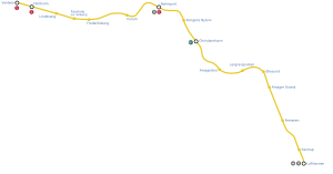
M2 (Copenhagen Metro)
| M2 | |||||||||||||||||||||||||||||||||||||||||||||||||||||||||||||||||||||||||||||
|---|---|---|---|---|---|---|---|---|---|---|---|---|---|---|---|---|---|---|---|---|---|---|---|---|---|---|---|---|---|---|---|---|---|---|---|---|---|---|---|---|---|---|---|---|---|---|---|---|---|---|---|---|---|---|---|---|---|---|---|---|---|---|---|---|---|---|---|---|---|---|---|---|---|---|---|---|---|
|
The terminus, Lufthavnen, which is in high position
| |||||||||||||||||||||||||||||||||||||||||||||||||||||||||||||||||||||||||||||
| Gauge : | 1435 mm ( standard gauge ) | ||||||||||||||||||||||||||||||||||||||||||||||||||||||||||||||||||||||||||||
| Power system : | 750 = | ||||||||||||||||||||||||||||||||||||||||||||||||||||||||||||||||||||||||||||
|
|||||||||||||||||||||||||||||||||||||||||||||||||||||||||||||||||||||||||||||
Line M2 is a subway line on the Copenhagen Metro . It is shown in yellow on the network plan.
Route
The line has a length of 14.2 kilometers, of which almost eight kilometers run underground. Eight of the 16 stations are underground. The travel time for the entire line is around 24 minutes.
Your starting point is at Vanløse station in the western part of the Vanløse district of the same name . From there it runs through the center of Copenhagen to its southeastern end point Lufthavnen in the municipality of Tårnby . From Vanløse to Christianshavn station , the route is shared by the M1 line , after which the M1 continues south.
history
Line M2 was opened on October 19, 2002 on the section Nørreport - Lergravsparken . On May 29, 2003, the extension to Frederiksberg station took place , shortly afterwards on October 12, 2003 the extension to its current starting point in Vanløse was inaugurated. The last extension was inaugurated on September 28, 2007, when the first trains were able to run to their new terminus at Lufthavnen at Copenhagen Airport .
Tact
The clock frequency is usually 4–6 minutes. On the section between Vanløse-Christianshavn, trains run every two minutes during peak times.
| Time of day | Cycle (minutes) |
|---|---|
| 00: 00-05: 00 | 15th |
| 05: 00-07: 00 | 6th |
| 07: 00-10: 00 | 4th |
| 10: 00-15: 00 | 6th |
| 15: 00-18: 00 | 4th |
| 18: 00–24: 00 | 6th |

