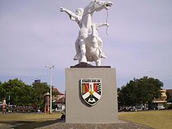
Magelang
| City of Magelang Kota Magelang Magelang |
||
|---|---|---|
|
|
||
| Coordinates | 7 ° 28 ′ 37 ″ S , 110 ° 13 ′ 0 ″ E | |
| Symbols | ||
|
||
| Basic data | ||
| Country | Indonesia | |
|
Geographical unit |
Java | |
| province | Jawa Tengah | |
| ISO 3166-2 | ID-JT | |
| height | 370 m | |
| surface | 18.1 km² | |
| Residents | 118,227 (2010) | |
| density | 6,524.7 Ew. / km² | |
| Website | www.magelangkota.go.id (Indonesian) | |
Magelang is a city in Indonesia on the island of Java with about 118,000 inhabitants.
geography
Magelang is the largest city in the Kedu Basin and the Magelang administrative district of the same name , which is located in the Central Java Province . The city lies between several volcanoes, some of them over 3000 meters high. To the west is the Sumbing and to the east the three volcanoes Telomoyo , Merbabu and the Merapi . Yogyakarta is about 40 kilometers south, while the provincial capital Semarang is about 60 kilometers to the north and Jakarta is less than 400 kilometers to the west. The Progo River flows in the west past the city towards the Indian Ocean.
Magelang has the status of a city ( Indonesian Kota ) and is divided into the three districts ( Kecamatan ) North Magelang ( Magelang Utara ), South Magelang ( Magelang Selatan ) and Central Magelang ( Magelang Tengah ), each of which has several villages ( Desa ).
history
The city was founded on April 11, 907. Historically, the old Buddhist temple complex Borobudur is located nearby .
The freedom fighter Diponegoro was arrested here during the Java War (1825-1830).
Facilities
Magelang has been a military base since colonial times when the city was part of the Dutch East Indies . There is a military academy and a military college in the city, as well as several universities.
sons and daughters of the town
- Hans Anton Maurenbrecher (1910–1966), Dutch single-handed sailor
- Marijke Merckens b. Ouwejan (born 1940), Dutch actress
- Dorothea Rosa Herliany (* 1963), Indonesian writer
- Zelin Resiana (* 1972), Indonesian badminton player
- Lenny Permana (* 1975), Australian badminton player
- Kurniawan Dwi Yulianto (* 1976), Indonesian soccer player
- Andre Kurniawan Tedjono (* 1986), Indonesian badminton player


