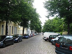
Mainzer Strasse (Berlin-Neukölln)
| Mainzer Strasse | |
|---|---|
| Street in Berlin | |
| Looking north | |
| Basic data | |
| place | Berlin |
| District | Neukölln |
| Created | 1898 |
| Connecting roads | Falkstrasse |
| Cross streets | (Selection) Flughafenstrasse, Boddinstrasse |
| Places | Boddinplatz |
| use | |
| User groups | Pedestrian traffic , bicycle traffic , car traffic |
| Technical specifications | |
| Street length | 710 meters |
The Mainzer Strasse in the district of Neukoelln in Berlin, close to the Tempelhof Airport area, starts at the Karl Marx Street and ends at the rolling mountain road. It was named after the city of Mainz and got its name on November 4, 1898.
Originally, Mainzer Strasse bordered in the north on what was then Berliner Strasse, which was only renamed Karl-Marx-Strasse in 1947, and in the south on Jägerstrasse, which was renamed Rollbergstrasse in 1950.
Mainzer Straße represents a field of social conflict. In 2005 mainly residents of non-German origin lived here. The tenement houses, some of which are 100 years old and largely spared the bombing of World War II, have mostly been renovated, and the street itself is still cobbled . The Berlin Senate wants to protect the street within the area between Karl-Marx-Straße, Hermannstraße and Flughafenstraße from social decline by means of Senate funding.
Because of the poor economic situation of their residents, the few restaurants and bars have a hard time and are struggling to survive. The measures that have now begun, which go back to the district management introduced by the Berlin Senate in 1999 , are intended to stabilize the situation in this street with “special development needs”.
Particularly noteworthy is the Neukölln Evangelical School , which has existed in Mainzer Strasse for over 60 years. It consists of the primary school (1st – 6th grade), the lower secondary level (7th – 10th grade), which is a comprehensive school, and the new upper level, which was introduced in the 1990s. Religion is a compulsory subject for all classes .
Web links
-
Mainzer Strasse. In: Street name lexicon of the Luisenstädtischer Bildungsverein (near Kaupert )
- Berliner Strasse . In: Luise.
- Jaegerstrasse . In: Luise.
- Karl-Marx-Strasse near Luise
- Rollbergstrasse near Luise
- Neighborhood management Flughafenstrasse, Neukölln, Berlin
Coordinates: 52 ° 28 ′ 51 ″ N , 13 ° 25 ′ 40 ″ E
