Majdal Anjar
|
Majdal Anjar مجدل عنجر |
||

|
||
| State : |
|
|
| Governorate : | Bekaa | |
| District: | Pay | |
| Coordinates : | 33 ° 42 ' N , 35 ° 54' E | |
| Height : | 970 m | |
| Area : | 25.6 km² | |
| Residents : | 23,000 (2006) | |
| Population density : | 898 inhabitants per km² | |
| Time zone : | UTC + 2 | |
| Mayor : | Sami El Ajame | |
| Website : | ||
|
|
||
Majdal Anjar ( Arabic مجدل عنجر, also transcribed Majdel Anjar ) is a middle town in the district of Zahlé of the Bekaa governorate in the Bekaa plain in Lebanon with 23,000 inhabitants (2006).
The city is located with an area of 25.64 km² on the Beirut - Damascus road about 5 km from the Syrian border - the Masnaa border station is located directly behind the city - at an altitude of 970 m. Beirut is 55 km away and Damascus is 57 km away. The village of small Anjar, predominantly inhabited by Armenians, with the remains of its ancient settlement and relics of the Umayyads is located a few kilometers to the north.
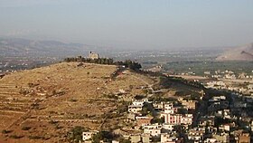
A former church, now called the castle, sits enthroned on a hill above the city.
Currently (January 2011) there is a travel warning from the German Foreign Office for the city.
