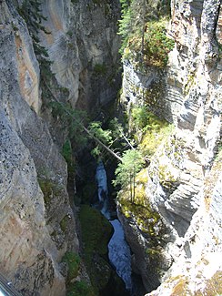
Maligne River (Athabasca River)
| Maligne River | ||
|
Maligne Canyon |
||
| Data | ||
| location | Alberta (Canada) | |
| River system | Mackenzie River | |
| Drain over | Athabasca River → Slave River → Mackenzie River → Arctic Ocean | |
| Headwaters | north of Replica Peak 52 ° 30 ′ 33 ″ N , 117 ° 28 ′ 7 ″ W |
|
| Source height | approx. 2280 m | |
| muzzle | 8 km northeast of Jasper in the Athabasca River Coordinates: 52 ° 56 '1 " N , 118 ° 2' 0" W 52 ° 56 '1 " N , 118 ° 2' 0" W |
|
| Mouth height | 1019 m | |
| Height difference | approx. 1261 m | |
| Bottom slope | approx. 18 ‰ | |
| length | approx. 70 km | |
| Catchment area | 908 km² | |
| Discharge at the gauge near Jasper A Eo : 908 km² |
MQ 1916/1997 Mq 1916/1997 |
16 m³ / s 17.6 l / (s km²) |
| Flowing lakes | Maligne Lake , Medicine Lake | |
The Maligne River ( [məˈliːn ˈɹɪvə] ) is a right tributary of the Athabasca River in the Canadian province of Alberta .
The Maligne River rises north of Replica Peak in the Canadian Rockies . The river flows north. It flows into the southern part of Maligne Lake , which it leaves again at the northern end of the lake. It continues to flow north. It flows through Medicine Lake , Maligne Canyon and finally flows 8 km northeast of Jasper into the Athabasca River.
The Maligne River is approximately 70 km in length and runs entirely within Jasper National Park . The catchment area covers 908 km². The mean discharge is 16 m³ / s.
Web links
Individual evidence
- ↑ a b Maligne River at the gauge near Jasper - hydrographic data from R-ArcticNET
