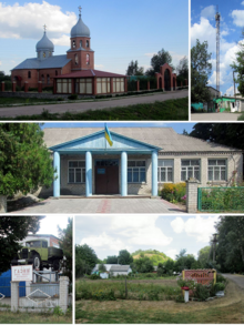
Manschelija
| Manschelija | ||
| Манжелія | ||

|
|
|
| Basic data | ||
|---|---|---|
| Oblast : | Poltava Oblast | |
| Rajon : | Hlobyne district | |
| Height : | 98 m | |
| Area : | 9.417 km² | |
| Residents : | 929 (2009) | |
| Population density : | 99 inhabitants per km² | |
| Postcodes : | 39062 | |
| Area code : | +380 5365 | |
| Geographic location : | 49 ° 20 ' N , 33 ° 39' E | |
| KOATUU : | 5320685401 | |
| Administrative structure : | 3 villages | |
| Address: | вул. Чаврікова, буд. 11 39062 с. Манжелія |
|
| Website : | Official website of the district council | |
| Statistical information | ||
|
|
||
Manschelija ( Ukrainian Манжелія ; Russian Манжелия Manschelija ) is a village in the Ukrainian Poltava Oblast with about 900 inhabitants (2009).
The village, founded at the end of the 16th / beginning of the 17th century, is the administrative center of the 78.257 km² district council of the same name in the east of Hlobyne district , on the border with Koselschtschyna district , to which the northern village of Witky ( Вітки , ⊙ ) with about 5 inhabitants and Lamane ( Ламане , ⊙ ), southwest of Manschelija, with about 290 inhabitants.
The village is located at an altitude of 98 m on the right bank of the Psel , a left tributary of the Dnieper , 33 km east of the district center Hlobyne and about 85 km southwest of the Oblast center Poltava . The T-17-21 territorial road runs through the village .
Web links
- Municipal Council website on rada.info (Ukrainian)
Individual evidence
- ↑ Official website of the district council ; accessed on April 1, 2020 (Ukrainian)
- ↑ history Manschelija in the history of the towns and villages of the Ukrainian SSR ; accessed on April 1, 2020 (Ukrainian)
- ^ Website of the district council on the official website of the Verkhovna Rada ; accessed on April 1, 2020 (Ukrainian)


