Marten brook
| Marten brook | ||
|
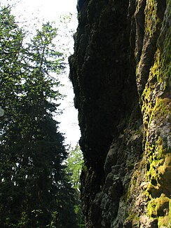
The gorge of the Marderbach |
||
| Data | ||
| location | District of Gotha , Thuringian Forest , Thuringia , Germany | |
| River system | Elbe | |
| Drain over | Schmalwasser → Apfelstädt → Gera → Unstrut → Saale → Elbe → North Sea | |
| origin | Confluence of the left and right Marder Bach 50 ° 47 '22 " N , 10 ° 38' 33" O |
|
| muzzle | at Tambach-Dietharz in the Schmalwasser Coordinates: 50 ° 47 '24 " N , 10 ° 38' 0" E 50 ° 47 '24 " N , 10 ° 38' 0" E |
|
| Mouth height |
460 m above sea level NN
|
|
| length | 2.2 km including the right Marderbach | |
The Marderbach is a right-hand tributary of the Schmalwassers in the Middle Thuringian Forest near Tambach-Dietharz .
Location and course
The Marderbach is part of the Elbe im Saale - Apfelstädt catchment area. It arises from the confluence of its two source brooks, the Left Marderbach to the north and the Right Marderbach to the south . Measured from the source of the right Marderbach, the longer of the two source brooks, it is about 2.2 km long. It rises east of the Kleiner Mittelrain at an altitude of 655 m above sea level. NN (right Marderbach) or south of the Vogelherdskopf in 630 m above sea level. NN (left Marderbach) and flows out at 460 m above sea level. NN in the narrow water. Its lower course runs in a narrow ravine and is protected as an area natural monument.
geology
The rocks in the Marderbachtal are up to 25 m high and are formed by the Bielstein conglomerate , a feldspar-rich quartz porphyry conglomerate from the Rotliegend period .
Bach ecology
The Marderbach is a typical low mountain range with rapid drainage and stony, creepy brook sediment. It is the natural habitat of the brown trout , which depends on clean water, and the reproduction site of the fire salamander .
vegetation
The mighty, narrow-crowned spruces ( Picea abies ) are remarkable . They are considered autochthonous , so their genetic material was created on site, was not brought in for forestry and is considered to be adapted to the local conditions. Some specimens are therefore also protected as seed trees by forestry. In addition, the silver fir ( Abies alba ) , which is rare and endangered in Thuringia, also occurs in a few specimens in the area natural monument .
particularities
The rocks of the Marderbachklamm are covered with water, which freezes to icicles and garlands of ice when it is frosty.
literature
- Evangelical Lutheran Church Community Apfelstädt (Ed.): The apple city. A river through the ages . Self-published, Weimar 2000, p. 248 .
