Maria (atoll)
| Maria | ||
|---|---|---|
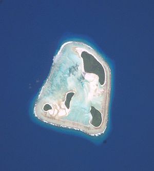
| NASA image of Maria Atoll | ||
| Waters | Pacific Ocean | |
| archipelago | Austral Islands | |
| Geographical location | 21 ° 48 ′ S , 154 ° 41 ′ W | |
|
|
||
| Number of islands | 4th | |
| Main island | Île du Nordet | |
| Land area | 1.3 km² | |
| Lagoon area | 5 km² | |
| Residents | uninhabited | |
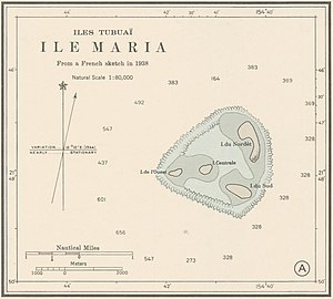
| Nautical chart from 1944 | ||
The atoll Maria (French: Ilôts Maria or Îles Maria ), also known as Hull Island or Nororotu , is a group of four uninhabited islands that belong to the Austral Islands , more precisely to the group of Tubuai Islands in the southern Pacific Ocean . The islands are the furthest west and north of the Austral group.
geography
Maria is an atoll that is well advanced in its development , the geologically oldest of the Tubuai group, whose volcanic central island sank a long time ago. Only the four motus sitting on the fringing reef are left. The lagoon, which is surrounded by a ring-shaped reef, is largely silted up.
The individual islands are named after their location in the atoll:
- Île du Sud
- Île Centrale
- Ile de l 'Ouest
- Île du Nordet
Île du Nordêt, the largest of the four, measures just 2 × 1 km. All islands consist of coral sand and debris and only protrude slightly above the sea surface. They have a total land area of 1.3 km². The area of the lagoon measures five square kilometers.
Flora and fauna
The botanist Raimond Fosberg from the University of Hawaii visited Maria in 1934 and found an undisturbed habitat. All four islands of the atoll were covered by an open tropical forest, which was composed mainly of Pisonia grandis , heliotropes of the species Heliotropium foertherianum (synonyms: Argusia argentea and Tournefortia argentea ) and Pandanus tectorius . Scaevola taccada bushes grew in the edge areas .
Meanwhile, Maria's flora is no longer untouched. On behalf of the administration of French Polynesia , a biological research expedition examined all four motu of the Maria Atoll on April 11 and 12, 2003 with the primary aim of determining the occurrence of threatened bird species. The scientists registered a vegetation with only 24 indigenous vascular plants (4 fern species and 20 seed plants ). In addition, three species of cultivated plants were found on the islands , which were probably introduced in the late 1930s to 1980s when coconut palms were established on the Île du Nordêt . The abandoned plantations, which are now densely overgrown with secondary vegetation, cover about half of the land area of the North Island and a small part of the South Island. The vegetation cover of the other two islands is largely undisturbed.
Maria is home to several marine bird species in significant stocks, of which the red-tailed tropical birds , frigate birds , white-bellied booby and red-footed booby also breed there. The presence of the Pacific rat ( Rattus exulans ) suggests that the islands were at least temporarily visited by Polynesians. A variety of land hermit crabs have settled in the abandoned coconut plantations, they are also in the altheimischen groves of Pandanus tectorius and Neisosperma oppositifolia : (synonym Ochrosia oppositifolia to find where they feed on the fallen Füchten).
history
Since there is no fresh water source, Maria was probably never permanently inhabited. The New Zealand anthropologist Peter Buck suspected, however, that the islands could have served as a landmark and a stopover on the early Polynesians' trade voyages between the more southern, inhabited Australian and Cook Islands . Targeted archaeological investigations have not yet been carried out.
A traditional collection of legends from Rurutu , which was transferred in writing at the end of the 19th century, tells of the journey of the king's son Amaiterai, a mythical hero of the island. He is sent to “the end of the world” by his father to gain divine wisdom. On the way back via New Zealand and the Cook Islands, he also touches the Atoll Maria, where he founds a marae until his mission is fulfilled on Rurutu and he takes over the reign from his father. The French Jean Guilin, author of a travel guide to the Austral Islands, concludes that Maria was once settled. So far, however, there is no archaeological evidence that this legend is true.
The island of Maria belonged to the Kingdom of Rimatara, which was independent until 1889. Rimatara submitted to the Protectorate of France on March 29, 1889 under Queen Tamaeva IV. The final annexation took place in 1900, together with Rimatara Maria became a French colony.
The atoll is named after the whaling ship Maria from Nantucket , whose captain George Washington Gardner (1778-1838) discovered it in 1824.
Another early visitor was Lieutenant Commander John Percival (April 3, 1779 - September 7, 1862), also known as Mad Jack Percival, commander of the USS Dolphin . The Dolphin crossed the Pacific in search of the mutiners of the American whaling ship Globe . On July 4, 1826, the Dolphin reached the island of Maria and launched two dinghies that circled the atoll. On the beach of the North Island, the sailors collected a lot of bird eggs within a very short time, as the birds were very numerous and completely unafraid of humans. The men did not enter the interior of the island, nor did they find any evidence of residents. Percival, who believed himself to be the first to discover it, named the island "Hull" after Commodore Isaac Hull (March 9, 1773 - February 13, 1843), the commander in chief of the United States Pacific Squadron.
John R. Sands, the captain of the whaling barque Benjamin Tucker , christened the island "Sands Island" on October 19, 1845, as he too believed himself to be the first to discover it.
Jules Dumont d'Urville passed the atoll with his ship Astrolabe without going ashore. He writes in his travelogue about the island of Maria:
“Beyond Rimatara, at latitude 21 ° 48 'south and longitude 157 ° 14' east, there is a small island surrounded by the ocean with a coral fringe that is beset by breakers. [It is] a mile long and about three hundred meters wide. Their surface was covered with undergrowth. "
Politics and administration
The uninhabited islands are administered by the municipality ( commune associée ) Amaru of the municipality of Rimatara ( Commune de Rimatara ) and politically belong to French Polynesia .
Individual evidence
- ↑ Bernard Salvat, Tamatoa Bambridge, Donatien Tanret, Jerôme Petit (eds.): Environnement Marin des Îles Australes, Polynésie Française, Tahiti 2015 , p. 205
- ^ Dieter Mueller-Dombois and F. Raymond Fosberg: Vegetation of the tropical Pacific islands . Springer-Verlag, New York 1998
- ^ Jean Yves Meyer: Report de mission sur l'atoll de Maria (Archipelago des Australes). Délégation à la Recherche Gouvernement de la Polynésie française, Papeete, 2013
- ↑ Ray Pierce, Philippe Raust, Graham Wragg: Report on on avifauna Survey of atolls in the Tuamotu and Austral Archipelagos, French Polynesia . New Zealand Agency for International Development, Contract Report No. 638, May 2003
- ^ Peter Buck: Vikings of the Sunrise. New York 1938, p. 170
- ↑ Alain Babadzan: De l'orally à l'écrit - les puta Tupuna de Rurutu. In: Journal de la Société des océanistes, Volume 35 (65), 1979, p. 229
- ↑ Jean Guillin: L'Archipel des Australes. Editions A. Barthélémy & Editions Le Motu, Avignon, 2001, ISBN 2-87923-138-8
- ↑ Jean-Louis Tamatoa Candelot: Opera-bouffe sous les tropiques - Lorsque deux petits royaumes voulurent devenir anglais (Histoire de Rurutu et Rimatara). In: Tahiti-Pacifique magazine, July 1999
- ^ John Dunmore: Who's Who in Pacific Navigation, Melbourne University Press 1992, p. 115, ISBN 0-522-84488-X
- ↑ Hiram Paulding: Journal of a Cruise of the United States Schooner Dolphin, along the islands of the Pacific Ocean: a visit to the Mulgrave Islands in pursuit of the mutineers of the whaleship Globe . G. & C. Carvill, New-York 1831, pp. 233-236
- ^ Alexander George Findlay: A directory for the navigation of the Pacific ocean . London 1851, pp. 800-801
- ↑ [1] >


