Mariahout
| province |
|
| local community |
|
|
Area - land - water |
14.06 km 2 14.04 km 2 0.02 km 2 |
| Residents | 1,965 (Jan. 1, 2018) |
| Coordinates | 51 ° 32 ' N , 5 ° 34' E |
| Important traffic route |
|
| prefix | 0499 |
| Postcodes | 5465, 5469, 5491, 5735, 5737-5738, 5741 |
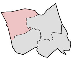
| Location of Mariahout in the municipality of Laarbeek | |
Mariahout is a small village in the southern Netherlands , about 20 kilometers north of Eindhoven . Mariahout has a population of around 1965 (as of January 1, 2018) and is the smallest village in the municipality of Laarbeek .
history
In the period after 1920, the heather in the western part of the municipality of Lieshout was reclaimed. Many new farms emerged , which together with an existing settlement formed the basis for a new village community. This community was officially founded in 1933 with the name Mariahout. This name is a contraction of Maria , the patron saint of the new parish , and Lieshout. Until 1997 Mariahout was part of the municipality of Lieshout. Since the municipality of Lieshout was dissolved on January 1, 1997, the village has been part of the new municipality of Laarbeek.
Personalities
- Guus Meeuwis (* 1972), Dutch pop singer , born in Mariahout
Web links
Individual evidence
- ↑ a b Kerncijfers wijken en buurten 2018 . In: StatLine . Centraal Bureau voor de Statistiek , February 1, 2019, accessed on March 4, 2019 (Dutch)
- ↑ Ad van der Meer, Onno Boonstra, (2006), Repertorium van Nederlandse gemeenten 1812–2006 , The Hague, DANS, ISBN 90 6984 495 8

