Mariara
| Mariara | ||
|---|---|---|
|
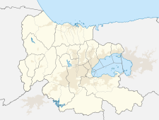
Coordinates: 10 ° 17 ′ N , 67 ° 43 ′ W Mariara on the map of Carabobo
|
||
| Basic data | ||
| Country | Venezuela | |
| State | Carabobo | |
| - in the metropolitan area | 110.131 | |
| City insignia | ||
| Detailed data | ||
| height | 0 m | |
| Time zone | UTC -4: 30 | |
| Nuestra Señora del Carmen Church in Mariara | ||
Mariara is the capital of the municipality ( Municipio ) Diego Ibarra in Carabobo in northern Venezuela .
Most of the 110,131 residents of the municipality live here.
The city is located between the Caribbean coast and Lake Valencia .
geography
location
Mariara is located in the northern center of Venezuela at the southern foot of the coastal mountains, a little north of Lake Valencia.
geology
The mountain range north of Mariara is also called Sierra de Mariara and consists largely of granite formations. Alexander von Humboldt said that the rocks consist of a very coarse-grained, almost porphyry-like granite in which the yellowish-white feldspar crystals emerge. The center of the mountain range in this region is called Rincón del Diablo. The western wing is called Viruelas and the eastern wing is called Chaparro. The Mariara hot springs are located a little northeast.
history
When the Europeans arrived in the mid-16th century, Caribbean tribes inhabited this region. The conquistador Vicente Díaz and his troops invaded this area around the year 1555. A battle was recorded in this area between his soldiers and the Indians.
The Tovar family owned large estates during the colonial period. Mariara was officially founded on December 3, 1781 by Bishop Mariano Martí . Alexander von Humboldt visited the village in the early 1800s.
Several of the first battles in the War of Independence (1811) took place in the area. One of the first battles of the War of Independence took place between Mariara and La Cabrera, on Lake Valencia, on July 19, 1811. There the Republicans fought under the leadership of the Marquis del Toro and the troops of the Spanish Crown under the leadership of Jacinto Iztueta.
politics
In the last election of the National Assembly (2010), the PSUV received 49% of the vote and Proyecto Venezuela 47.13%.
Economy and Infrastructure
traffic
The "Autopista Regional del Centro" motorway between Caracas and Valencia leads south directly past Mariara. West of Mariara is the motorway exit to Mariara and San Joaquin . A national road "Carretera Panamericana" leads from Maracay to Mariara and on to San Joaquin.
Public buildings
A small health center, Ambulatorio de Mariara, is located a little east of the town hall. There are some elementary schools and a high school.
Attractions
Mariara's Catholic Church is called Nuestra Señora del Carmen .
Web links
Individual evidence
- ↑ Population of the municipalities of Carabobos ( page no longer available , search in web archives ) Info: The link was automatically marked as defective. Please check the link according to the instructions and then remove this notice.
- ↑ von Humboldt, Alexander
- ^ Antczak, Andrej; Antzack, María Magdalena (2006): Los ídolos de las Islas Prometidas: Arqueología Prehispánica del Arquipiélago de los Roques. Equinoccio. Pág 512.
- ↑ History of Mariara (in Spanish)
- ^ Elections in Mariara (2010)


