Marr (Scotland)
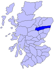
Marr is one of the six Committee Areas in Aberdeenshire , Scotland .
geography
Marr stretches across the upper reaches of the Dee and Don rivers and extends north at Huntly to the middle reaches of the Deveron . In the northwest, Marr is bounded by the Grampian Mountains , in the south by the mountain range of the Mounth .
Marr has 34,495 inhabitants (2005 update), the area is 1942 km². Marr covers almost half of Aberdeenshire with a share of 47% and is also the most sparsely populated area of Aberdeenshire with a population density of 12 inhabitants per km². The largest towns in Marr are Banchory (6359 inhabitants), Huntly (4362 inhabitants), Aboyne (2250 inhabitants), Alford (2098 inhabitants) and Ballater (1754 inhabitants). The residents of Marr are known as Màrnach in Gaelic .
economy
Marr is traditionally an agricultural district. Livestock and forestry in particular play a role here. In the east of the area, people are increasingly commuting to Aberdeen. There is also an increasing population in this area.
tourism
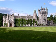
The Cairngorms National Park extends to the west of Marr . There are many castles and chateaux along the River Dee, the most famous of which is Balmoral Castle , the summer residence of the British Queen . The area around Balmoral is also known as Royal Deeside . The tourist infrastructure in this area is considered to be well developed.
Historic area Mar
The name Marr is derived from Mar , a historic district of Scotland. Mar extended over the area between the River Don in the north and the mountain range of the Mounth south of the River Dee deep into the area of the Grampian Mountains and thus over a large part of present-day Aberdeenshire. In the Middle Ages it was first under the rule of a mormaer , the mormaer of Mar , from the 12th century under Earl of Mar . It is not known if there was any connection between the two titles. Holders of the title Earl are only listed in a secure name order from the 13th century. The district was merged with Aberdeen even before the restructuring of the Scottish local government in 1889. At that time, the name Mar disappeared as an administrative district. Mar was (and still is) one of the five traditional landscapes of Aberdeenshire.
Web links
- Extensive information, detailed map, statistical data ( Memento from August 30, 2007 in the Internet Archive )
Coordinates: 57 ° 13 ′ 34.8 " N , 2 ° 46 ′ 38.1" W.


