Mawson's hats
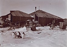
The Mawson's Huts (German: Mawson huts ) are wooden buildings on Cape Denison , Commonwealth Bay in the Australian Antarctic Territory in Antarctica , about 3000 km south of Hobart . These are the first buildings the Australians erected in Antarctica in the early 1910s. Today they are under monument protection.
meaning
The huts formed the base station for the scientific and geographical exploration of the south polar region by the Australasian Antarctic Expedition from 1911 to 1914 under the direction of the geologist and explorer Sir Douglas Mawson . The branch is one of the six stations still in existence in Antarctica, dating from the so-called " Golden Age of Antarctic Research ".
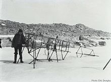
The expedition had established the first radio link from Antarctica to the Australian continent via a relay station on Macquarie Island. Mawson also brought the first aircraft to Antarctica, which was destroyed by a storm in Adelaide and converted into a propeller-driven sled.
Terrain and Buildings
The Main Hut , the main hut , consists of a lounge for 18 people, a workshop and a veranda. It is at the end of the Main Valley Boat Harbor . The memorial cross of the 1913 expedition is built on the western elevation.
The building complex consists of four wooden huts, two of which are still intact and two are ruins. The Transit Hut (ruin without a roof) is 30 m east of the Main Hut , the Magnetograph Hut (intact) and the Absolute Magnetic Hut (ruin without a roof) are located on the lake-facing side of Proclamation Hill , 260 m east of the Main Hut .
In addition to the buildings, there are landmarks of the scientific investigations, two overturned transmitter masts and other historical objects, for example canisters, wire and isolators of the transmitter, the memorial cross with plaques from the expeditions.
Monument protection
The climate in Commonwealth Bay is characterized by strong winds, snow and ice. The buildings were left to decay for years. Only expeditions by the Australian Antarctic Division since the late 1970s and since 1997 the private Mawson's Huts Foundation undertook conservation and securing work, especially against the decay of the roofs.
Since 1972, the 130 hectare area with the huts has been recognized as a Historic Site and Monument , declared an Antarctic Specially Protected Area and an Antarctic Specially Managed Area in 2004 , and entered the Australian National Heritage List in 2007 . In 2014, the protection as a specially managed area ASMA-3 expired with the entry into force of a new management plan for ASPA-162.
literature
- Australian Antarctic Division: Mawson's Huts Historic Site Management Plan 2007–2012 .
- R. Mackay: Ice, icon and identity: the meaning of Mawson's huts . In: J. Lydon, T. Ireland (Eds.): Object Lessons: Archeology & Heritage in Australia , 2005.
- D. Mawson: Home of the Blizzard: being the story of the Australasian Antarctic Expedition, 1911-1914 , 1915.
- M. Pearson: Expedition huts in Antarctica: 1899-1917 . In: Polar Record . Volume 28, No. 167, 1992, pp. 261-276.
Web links
- environment.gov.au : Australian National Heritage listing for Mawson's Huts and Mawson's Huts Historic Site
- mawsonshuts.aq : Home of the Blizzard - the Australasian Antarctic Expedition (English)
- mawsons-huts.org : The Mawson's Huts Foundation (English)
Individual evidence
- ↑ a b c d environment.gov.au : Mawsons Huts and Mawsons Huts Historic Site, Dumont D'Urville Station, EXT, Australia , in English, accessed on October 22, 2011 (with numerous images)
- ↑ a b environment.gov.au ( Memento of the original from August 15, 2011 in the Internet Archive ) Info: The archive link was automatically inserted and not yet checked. Please check the original and archive link according to the instructions and then remove this notice. (PDF; 51 kB): Mawson Huts and Mawson Hut Historic Site , in English, accessed on October 23, 2011
- ↑ Mawson's Huts, Cape Denison, Commonwealth Bay, George V Land, East Antarctica (PDF; 1.63 MB), Management Plan for Antarctic Specially Protected Area No. 162, accessed on June 22, 2016
Coordinates: 67 ° 0 ′ 30 ″ S , 142 ° 39 ′ 40 ″ E


