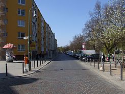
Maybachufer
| Maybachufer | |
|---|---|
| Street in Berlin | |
| Maybachufer at the corner of Schinkestrasse | |
| Basic data | |
| place | Berlin |
| District | Neukölln |
| Created | 1870s |
| Hist. Names |
Wiesenufer , street 45 |
| Connecting roads |
Planufer (northwest) , Weichselstrasse (southeast) |
| Cross streets |
Kottbusser Damm , Schinkestrasse , Hobrechtstrasse , Bürknerstrasse , Sanderstrasse , Friedelstrasse , Liberdastrasse , Nansenstrasse , Pannierstrasse |
| use | |
| User groups | Pedestrian traffic , bicycle traffic , car traffic |
| Technical specifications | |
| Street length | 1490 meters |
The Maybachufer is a street on the Landwehr Canal in the Berlin district of Neukölln and was named after the lawyer and politician Albert von Maybach .
history
The two-lane road is part of the so-called “ Reuterkiez ”, a once swampy meadow and bush area, which was developed in the mid-19th century due to its convenient location on the Landwehr Canal.
On a map from 1877 the road is shown as a meadow bank . In the development plan it appears as Straße 45 and was given its current name between 1882 and 1883. A weekly market was already taking place here between the industrial and residential buildings during this period . Today backyard factories and commercial yards are a reminder of the former industrial use. The rental house group Maybachufer 20/21 in connection with the buildings at Friedelstrasse 34 as well as Bürknerstrasse 1 and 29–32 are under monument protection . They were created in 1909 and 1910 based on designs by Reinhold Kiel and Karl Wolter.
Since 2008 there have been various stumbling blocks for Markus and Flora Goldstein, Lucie, Rosa and Selma Meyer and Georg Lichtenstein in front of house number 8 .
In guidebooks is Turkish market Maybachufer mentioned, Tuesdays and Fridays takes place here and already with the Munich Viktualienmarkt was compared.
Bicycle traffic
The Maybachufer is not equipped with cycle paths.
One of 17 permanently installed automatic wheel counting stations in Berlin has been on the street since 2016. Among all the places in the city with a counting point, the Maybachufer is the fourth most frequented place by bicycle traffic.
See also
Web links
- Maybachufer. In: Street name lexicon of the Luisenstädtischer Bildungsverein (near Kaupert )
- Entry in the Berlin State Monument List
- Entry in the Berlin State Monument List
- Das Maybachufer - Kreuzberger Chronik 2008, Edition 100, accessed on June 26, 2012.
Individual evidence
- ^ Ingrid Thienel: Urban growth in the industrialization process of the 19th century . de Gruyter, 1973, ISBN 978-3-11-003417-2 (accessed June 27, 2012).
- ↑ Rolf-Dieter Volmerig: Berlin: Contributions to the Geography of a Large City Area - Festschrift for the 45th German Geographers' Day in Berlin from September 30, 1985 to October 2, 1985 . Reimer, 1985, ISBN 978-3-496-00829-3 (accessed June 27, 2012).
- ↑ Our quarters. Website of the Reuterkiez district management, accessed on June 26, 2012.
- ↑ Wladimir Kaminer : I'm not a Berliner: A travel guide for lazy tourists . Goldmann Verlag, July 28, 2010, ISBN 978-3-89480-412-1 , p. 165 (accessed June 27, 2012).
- ↑ Berndt Schulz: At home in Berlin: declarations of love to the pristine corners of the city . Sutton Verlag GmbH, April 2011, ISBN 978-3-86680-781-5 , p. 34 (accessed June 27, 2012).
- ^ Jochen Overbeck: Viktualienmarkt vs. Maybachufer . In: Süddeutsche Zeitung , January 28, 2011, accessed on June 26, 2012.
- ↑ Traffic survey bike counter for Berlin: How many cyclists are there? Retrieved February 5, 2019 .
Coordinates: 52 ° 29 ′ 33.8 " N , 13 ° 25 ′ 49.4" E

