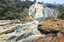
Mbéré (river)
| Mbéré | ||
|
Course of the Mbéré in the catchment area of the Schari (center left outer) |
||
| Data | ||
| location |
|
|
| River system | Shari | |
| Drain over | Logone Occidental → Logone → Shari → Lake Chad | |
| source | in Cameroon | |
| Source height | 1100 m | |
| muzzle | Confluence with the Vina and formation of the Logone Occidental Coordinates: 9 ° 5 ′ 20 ″ N , 16 ° 27 ′ 55 ″ E 9 ° 5 ′ 20 ″ N , 16 ° 27 ′ 55 ″ E |
|
| Mouth height | 375 m | |
| Height difference | 725 m | |
| Bottom slope | 2.9 ‰ | |
| length | 250 km | |
| Catchment area | 21,360 km² | |
| Discharge at the gauge 1337200 Mbere A Eo : 7430 km² |
NNQ (min. Month Ø) MNQ 1951–1979 MQ 1951–1979 Mq 1951–1979 MHQ 1951–1979 HHQ (max. Month Ø) |
7.8 m³ / s 15.6 m³ / s 114 m³ / s 15.3 l / (s km²) 316 m³ / s 588 m³ / s |
| Outflow A Eo : 21,360 km² at the mouth |
MQ Mq |
346 m³ / s 16.2 l / (s km²) |
| Left tributaries | Mambaka, Mandim, Koudini, Touldoro | |
| Right tributaries | Ngou | |
The Mbéré is a river in Central Africa and a source river of the Logone .
course
It rises north of Meiganga in the highlands of Cameroon , on the Baia plateau , at an altitude of about 1100 m. It runs mainly in an easterly - northeast direction through the Vallée du Mbéré National Park . After the mouth of the Ngou, the Mbéré first forms the border between Cameroon and the Central African Republic , and later the border between Cameroon and Chad . It joins the Vina 30 km north of the border triangle on the border between Chad and Cameroon .
ID
The information about the rivers of the region are partly different. In some cases, the Mbéré is equated with the Logone Occidental (western Logone), which unites with the Pendé and forms the Logone . On other maps it changes its name to Logone Occidental after the confluence with the Vina. Accordingly, the catchment areas with 7430 km² and a discharge of 114 m³ / s and 21,360 km² and a discharge of 346 m³ / s are given differently.
Hydrometry
The flow rate of the river was measured in m³ / s at the Mbere station

Individual evidence
- ↑ a b c d Evaluation hydrologique de l'Afrique Sub-saharienne, Pays de l'Afrique de l'Ouest.Retrieved November 23, 2014
- ↑ a b c PDF on the hydrology of Cameroon (French) Accessed August 24, 2018
- ↑ Excerpt from the German Colonial Lexicon (1920)
- ↑ International Boundary Study. Cameroon - Central African Republic Boundary

