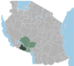
Mbozi
| Mbozi | |
|---|---|
 |
|
| Basic data | |
| Country | Tanzania |
| region | Songwe |
| Seat | Vwawa |
| surface | 9679 km² |
| Residents | 513,600 (2002) |
| density | 53 inhabitants per km² |
| ISO 3166-2 | TZ-31 |
Coordinates: 9 ° 7 ′ S , 32 ° 56 ′ E
Mbozi is a district in southwest Tanzania with over 500,000 inhabitants. Most of them belong to the Nyiha and Nyamwanga ethnic groups . Since 2016, Mbozi has belonged to the newly created Songwe region , before that to the Mbeya region .
Mbozi borders directly on Zambia and on the districts of Chunya, Mbeya-Land and Ileje. To the west is the Rukwa region .
The administrative seat is in Vwawa , which is on the main road from Dar es Salaam via Mbeya to Zambia via Tunduma .
The name of the district comes from the Moravian Mbozi mission station founded in 1899 near Vwawa, where the Moravian Church maintains a hospital and a school.
Administrative division
The following parishes exist in the district:
|
|
|
Individual evidence
- ↑ Entry on the Tanzania website ( Memento of the original dated May 30, 2012 in the web archive archive.today ) Info: The archive link was inserted automatically and has not yet been checked. Please check the original and archive link according to the instructions and then remove this notice.