Mesha (Daugava)
|
Mesha Межа́ |
||
|
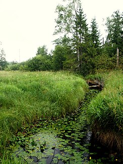
The upper reaches of the Mesha |
||
| Data | ||
| location | Tver , Smolensk ( Russia ) | |
| River system | Daugava | |
| Drain over | Düna → Baltic Sea | |
| source |
Valdai Heights , in the Nelidowo district, 56 ° 30 ′ 47 ″ N , 32 ° 58 ′ 36 ″ E |
|
| muzzle |
Düna near Dorischkino ( Sapadnaja Dwina Rajon ) Coordinates: 55 ° 43 ′ 8 " N , 31 ° 29 ′ 2" E 55 ° 43 ′ 8 " N , 31 ° 29 ′ 2" E
|
|
| length | 259 km | |
| Catchment area | 9080 km² | |
| Drain |
MQ |
61 m³ / s |
| Left tributaries | Beresa , Lutschessa , Obscha , Jelscha | |
| Right tributaries | Butakovka | |
| Medium-sized cities | Nelidowo | |
|
Location of the Mescha (Межа́) in the catchment area of the Daugava |
||
The Mescha ( Russian Межа́ ) is a left tributary of the Daugava in the Russian oblasts of Tver and Smolensk .
It rises on the Valdai heights and flows into the Daugava, which flows into the Baltic Sea near Riga .
The length of the Mescha is 259 km, its catchment area extends over 9080 km² and it has an average discharge of 61 m³ / s. The river is ice-covered between November and the end of March / April. The largest city on the river is Nelidowo . Important tributaries are Beresa , Lutschessa , Obscha and Jelscha on the left, as well as the Butakowka on the right.
The lower reaches are navigable but navigation is difficult due to driftwood.
Web links
- Rivers of Tver Oblast (Russian)

