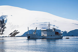
Mikkelsen Harbor
| Mikkelsen Harbor | ||
|---|---|---|
|
The Russian MS Grigory Michejow in Mikkelsen Harbor (January 2009) |
||
| Waters | Orléans Street | |
| Land mass | Trinity Island , Palmer Archipelago | |
| Geographical location | 63 ° 53 '47 " S , 60 ° 46' 34" W | |
|
|
||
| width | 3.5 km | |
| depth | 2.8 km | |
| Islands | D'Hainaut Island , Islote Viña del Mar | |
|
The small island D'Hainaut in Mikkelsen Harbor, with the Argentine refuge and numerous gentoo penguins , and in the background the glaciated cliffs of Trinity Island |
||
The Mikkelsen Harbor is a small bay on the south coast of Trinity Island in the Palmer Archipelago off the western coast of the Antarctic Graham Lands . It lies between Cape Skottsberg in the west and Borge Point in the east.
The bay was discovered during the Swedish Antarctic Expedition (1901–1903) under the direction of Otto Nordenskjöld . Neither the time of naming nor the namesake are certain. It is likely that it was named around 1913 by the Scottish geologist David Ferguson (1857-1936), who surveyed the bay between 1913 and 1914. The namesake of the Danish polar explorer Ejnar Mikkelsen (1880–1971), the Norwegian whaler Peder Mikkelsen († 1910), but above all Otto H. Mikkelsen according to Stewart. The latter was a Norwegian diver who pulled the damaged hull of the research vessel Pourquoi Pas? by the French polar explorer Jean-Baptiste Charcot on December 8, 1908, not far from the Norwegian whaling station on Deception Island .
Web links
- Mikkelsen Harbor in the Geographic Names Information System of the United States Geological Survey (English)
- Mikkelsen Harbor on geographic.org (English)
Individual evidence
- ^ John Stewart: Antarctica - An Encyclopedia . Vol. 2, McFarland & Co., Jefferson and London 2011, ISBN 978-0-7864-3590-6 , p. 1037 (English).


