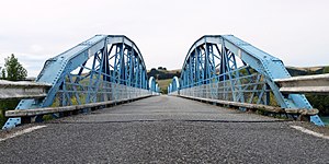
Miller's Flat Bridge
Coordinates: 45 ° 39 ′ 51 ″ S , 169 ° 24 ′ 34 ″ E
| Miller's Flat Bridge | ||
|---|---|---|
| Miller's Flat Bridge over the Clutha River | ||
| use | Road traffic | |
| Crossing of | Clutha River | |
| place | Millers Flat , Central Otago District | |
| construction | Arch bridge | |
| overall length | 176.2 m | |
| width | 4.1 m | |
| start of building | Mid-1897 | |
| completion | Late 1898 | |
| opening | February 23, 1899 | |
| construction time | 1.5 years | |
| planner | Robert Hay | |
| location | ||
|
|
||
| Above sea level | 46 m | |
The Millers Flat Bridge is an arch bridge over the Clutha River in the Central Otago District of the Otago region on the South Island of New Zealand .
geography
The bridge is located in Millers Flat , a small settlement around 15 km southeast of Roxburgh . The bridge connects the part of the settlement east of the Clutha River with the New Zealand State Highway 8, which runs along the west side of the river .
history
Since the Otago gold rush in the 1860s, many gold prospectors have been drawn to central Otago , including the Clutha River . The settlements that arose on both sides of the long river made an efficient and safe crossing of the river necessary. In what was then Tuapeka County, a kind of " Bridge Committee " was formed, which in 1895 requested a bridge to cross the river in a petition addressed to the Tuapeka County Council and the government .
The request of the settlers was granted and the engineer Robert Hay (1847–1928) from Dunedin was won over for the project . He drafted the construction plans and the design of the bridge in February 1896. After several discussions among the settlers and the decision-makers about the location of the bridge and its construction costs, the construction project finally started in mid-1897. The company J. and A. Andersons from Christchurch was commissioned with the construction. Fatal accidents caused some people involved to doubt the safety standards of the company and so construction dragged on for 1 1/2 years.
At the end of 1898 the construction of the bridge was finally completed and the opening was announced for January 1899, but since Prime Minister Richard Seddon (1845–1906) had no free date to open the bridge, the inauguration had to be postponed to February 23, 1899.
Bridge construction
The 176.2 m long Millers Flat Bridge is a steel bridge , in addition to its anchoring to the banks of the Clutha River pairs embedded in the river bed to six filled with concrete cylinders made of cast iron rests. The piles are sunk nine meters into the river bed. The four arches made of steel, arranged in pairs on both sides of the roadway, rise 4.9 m above the base. The carriageway has a width of 4.1 m and is made of wood with a covering layer of asphalt.
Monument protection
The Millers Flat Bridge was classified by Heritage New Zealand in the Historic Place Category 2 on April 19, 1990 and thus placed under monument protection.
Web links
- Miller's Flat Bridge . The Institution of Professional Engineers New Zealand, April 14, 2016,accessed August 7, 2017.
- Miller's Flat Bridge . Living Heritage,accessed August 7, 2017.
- Miller's Flat Bridge . Heritage New Zealand,accessed August 7, 2017.
Individual evidence
- ↑ Topo250 maps . Land Information New Zealand , accessed August 7, 2017 .
- ↑ a b Miller's Flat Bridge . The Institution of Professional Engineers New Zealand , April 14, 2016, accessed August 7, 2017 .
- ↑ Miller's Flat Bridge . Heritage New Zealand , accessed August 7, 2017 .


