
Miller's Flat
| Miller's Flat | ||
| Geographical location | ||
|
||
| Coordinates | 45 ° 40 ′ S , 169 ° 25 ′ E | |
| Region ISO | NZ-OTA | |
| Country |
|
|
| region | Otago | |
| District | Central Otago District | |
| Ward | Roxburgh Ward | |
| Residents | 93 (2013) | |
| height | 46 m | |
| Post Code | 9572 | |
| Telephone code | +64 (0) 3 | |
| Photography of the place | ||
 Junction from State Highway 8 to Millers Flat (left) |
||

Millers Flat is a small settlement in the Central Otago District of the Otago Regionon the South Island of New Zealand .
Origin of name
Originally called Māori Ovens Hill because of the many earth ovens , the settlement was later named by Walter Miller , an early settler in the area who ran a farm from 1849. The Oven Hill Road northeast of the village still reminds of the original name .
geography
The settlement is located around 15 km southeast of Roxburgh on the Clutha River . Most of the settlement is on the east side of the river. The New Zealand State Highway 8 connects the settlement with Milton in the southeast and Roxburgh and Alexandra in the north. The closest settlements are Ettrick and Raes Junction . A road on the east bank of the Clutha River leads to Teviot , which, like Ettrick, is northwest of the settlement.
history
The Roxburgh Branch , a branch line of the Main South Line , ran to Millers Flat from 1925 and was the end point for about two and a half years until the section to Roxburgh was opened. The line was closed in 1968, but the station platform and some embankments are still there.
population
At the 2013 census, the town had 93 inhabitants.
economy
The main livelihood in the region is fruit growing.
Education
With the Millers Flat School founded in 1886, the settlement has a primary school for grades 1-8. and as of 2017 a total of 36 students.
Sightseeing
The steel Millers Flat Bridge , a road bridge known as the “ Blue Bridge ” because of its blue paint , crosses the Clutha River in Millers Flat . It was completed in January 1899 and inaugurated in February 1900. All of the bridge material was imported from England at the time. The steel arch bridge was listed on the New Zealand Historic Places Trust Register as No. 5217 .
In the settlement is the church of St John the Baptist belonging to the diocese of the Anglican Church in Aotearoa, New Zealand and Polynesia in Dunedin . This concrete church opened in 1914. It has a rose window with stained glass .
The Millers Flat war memorial, erected in 1922, lists the names of those who died in the settlement during the First and Second World Wars .
tourism
There is a campsite at Millers Flat, and recreational activities focus on water sports, fishing and hiking.
Photo gallery

Miller's Flat War Memorial
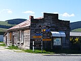
Old wooden building, road to Teviot

Miller's Flat Bridge ( Blue Bridge ) over the Clutha River
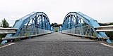
Miller's Flat Bridge over the Clutha River


literature
- Helga Neubauer: Miller's Flat . In: The New Zealand Book . 1st edition. NZ Visitor Publications , Nelson 2003, ISBN 1-877339-00-8 , pp. 824 f .
Web links
Individual evidence
- ↑ a b 2013 Census QuickStats about a place: Teviot . Statistics New Zealand , accessed on August 7, 2017 (English, StatsMap: Meshblock analysis from the interactive map).
- ↑ a b Neubauer: Miller's Flat . In: The New Zealand Book . 2003, p. 824 .
- ↑ a b The best things to see and do in Miller's Flat . In: New Zealand Herald . NZME. Publishing , October 7, 2016, accessed August 7, 2017 .
- ↑ Topo250 maps . Land Information New Zealand , accessed August 7, 2017 .
- ^ Miller's Flat School . Education Review Office , accessed August 7, 2017 .
- ↑ Miller's Flat Bridge . Heritage New Zealand , accessed November 9, 2016 ( New Zealand Historic Places Trust entry April 19, 1990).
- ↑ Miller's Flat was memorial . In: New Zealand History . Ministry for Culture & Heritage , accessed August 7, 2017 .