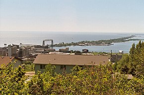
Minnesota Point
| Minnesota Point | ||
 Minnesota Point (in the background) |
||
| Geographical location | ||
|
|
||
| Coordinates | 46 ° 44 ′ N , 92 ° 4 ′ W | |
| Waters 1 | Lake Superior | |
| length | 11 km | |
| width | 150 m | |
Minnesota Point (also Park Point , formerly La Pointe ) is an island and former peninsula at the confluence of the Saint Louis River in Lake Superior . It belongs to Duluth , Minnesota . With an average width of 150 meters and a length of eleven kilometers, it is considered the longest sandbank in a freshwater lake.
Minnesota Point is part of a continuous sand deposit between Duluth and Superior , Wisconsin, at the mouth of the Saint Louis River in Lake Superior . A small natural run separates Minnesota Point in the northwest from the much shorter Wisconsin Point in the southwest. The geological formation took place in two steps: on the one hand, sand from the Upper Lake collected at the Bay of Duluth and Superior, on the other hand the sediments of the Saint Louis River and the Nemadji River were deposited there and gave rise to the sandbank.
Minnesota Point has a population of around 1,500. It is a popular recreational area and has its own airfield ( Sky Harbor Airport ). The peninsula was separated from the mainland by a canal in 1871 and became an island. Minnesota Point is connected to Duluth by the Aerial Lift Bridge .
Web links
- Information about Park Point Trail (English)
