
Mirzapur
| Mirzapur | |||
|---|---|---|---|
|
|||
| State : |
|
||
| State : | Uttar Pradesh | ||
| District : | Mirzapur | ||
| Location : | 25 ° 9 ′ N , 82 ° 35 ′ E | ||
| Height : | 89 m | ||
| Residents : | 234,871 (2011) | ||

Mirzapur ( Hindi : मिर्ज़ापुर , Urdu : مرزا پور; Mirzāpur , [ mirˈzɑːpʊr ]; officially Mirzapur-cum-Vindhyachal ) is a city in the northern Indian state of Uttar Pradesh .
The city is located in the east of Uttar Pradesh on the Ganges , around 50 kilometers west of Varanasi and 80 kilometers east of Prayagraj . Together with the neighboring Vindhyachal Mirzapur forms administratively the municipality ( municipality ) Mirzapur-cum-Vindhyachal . Together, the two cities have around 230,000 inhabitants (2011 census). The city is the administrative seat of the Mirzapur District and the Mirzapur Division .
Mirzapur is located on a high bank on the south side of the Ganges. Ghats lead directly from the city to the river. The village of Vindhyachal (Bindhachal), about five kilometers to the west, is an important pilgrimage destination thanks to the temple of the goddess Vindhyavasini. The national highway National Highway 7 and the railway line from Prayagraj to Mughalsarai run through Mirzapur .
At the end of the 18th century, Mirzapur was an important trading post, from which cotton from central India and grain from the Doab were shipped to Calcutta . Mirzapur owed its importance to its location at the highest point on the Ganges, which could be reached by large steamers. After the completion of a railway line to Prayagraj in 1864, Mirzapur rapidly lost its importance again.
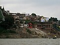
Mirzapur seen from the Ganges
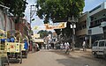
Street scene in Mirzapur

