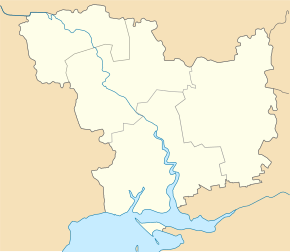
Mishkovo-Pohorilowe
| Mishkovo-Pohorilowe | ||
| Мішково-Погорілове | ||

|
|
|
| Basic data | ||
|---|---|---|
| Oblast : | Mykolaiv Oblast | |
| Rajon : | Vitovka district | |
| Height : | 31 m | |
| Area : | 46.11 km² | |
| Residents : | 5,484 (2004) | |
| Population density : | 119 inhabitants per km² | |
| Postcodes : | 57215 | |
| Area code : | +380 512 | |
| Geographic location : | 47 ° 0 ' N , 32 ° 6' E | |
| KOATUU : | 4823383001 | |
| Administrative structure : | 1 village, 1 settlement | |
| Address: | вул. Миру 38 57 214 с. Мішково-Погорілове |
|
| Website : | City council website | |
| Statistical information | ||
|
|
||
Mishkowo-Pohorilowe ( Ukrainian Мішково-Погорілове ; Russian Мешково-Погорелово Meschkowo-Pogorelowo ) is a village in the Ukrainian Oblast of Mykolaiv with about 5500 inhabitants (2004).
The village, founded in 1810, is the center of the district council of the same name in Vitovka district , to which the settlement Svjatomykolajiwka ( Святомиколаївка ⊙ ) with about 700 inhabitants belongs.
Mishkowo-Pohorilowe is located on the lower reaches of the Inhul between the oblast capital Mykolaiv in the southwest and the urban-type settlement Woskressenske in the northeast. The M 14 / E 58 and N 11 highways lead past the village .
Web links
Commons : Mischkowo-Pohorilowe - collection of pictures, videos and audio files
Individual evidence
- ↑ Mishkovo-Pohorilowe on the official website of the Verkhovna Rada ; accessed on August 1, 2017 (Ukrainian)


