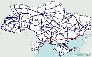
M 14 (Ukraine)
| M14 trunk road in Ukraine | |

|
|
| |
|
| map | |
| Basic data | |
| Operator: | |
| Overall length: | 624.3 km |
|
Oblasts : |
|
| M 14 between Kostjantyniwka and Pryasowske | |
The M 14 is a trunk road of international importance in Ukraine . It leads from Odessa in an easterly direction and largely parallel to the Black Sea coast via Mykolaiv , Cherson , Melitopol , Berdjansk and Mariupol to the Russian border at Taganrog . Until 1991, the line was part of the M 23 in the Soviet highway network. In Russia, the section from the border to Rostov-on-Don still bears this name today.
course
- 0 km - Odessa
- Mykolaiv Oblast
- 38 km - Koblewe
- 109 km - Mykolaiv
- 171 km - Kherson
- 216 km - Tjahynka
- 248 km - Beryslaw
- 258 km - Nowa Kachowka
- 293 km - turnoff to Novooleksiyivka and the Crimean peninsula
- 353 km - Nyschni Torhaji
- Zaporizhia Oblast
- 442 km - Melitopol
- 465 km - Pryasovské
- 423 km - Prymorsk
- 461 km - Berdyansk
- 476 km - Ossypenko
- Donetsk Oblast
- 520 km - Mokvin
- 548 km - Mariupol
- 589 km - Novoazovsk

