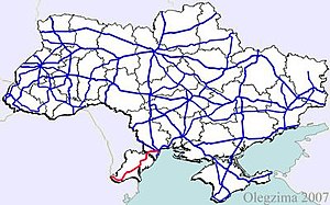
M 15 (Ukraine)
| M15 trunk road in Ukraine | |

|
|
| |
|
| map | |
| Basic data | |
| Operator: | |
| Overall length: | 244.4 km |
|
Oblasts : |
|
The M 15 is a trunk road of "international importance" in Ukraine . It leads from Odessa in a south-westerly direction to Ismajil on the Danube , which here also forms the state border with Romania . Before 1991, the line was a section of the A 290 in the Soviet highway network. It is part of the European route 87 . A short section of the M 15 runs through Moldovan territory between Mayaky and Starokosatsche near Palanca .
course
| 0 km | Odessa |
| 24 km | Mayaky (near Biljajiwka ) |
| 42 km | Palanca (Moldova) |
| 54 km | Starokosatsche |
| 70 km | Monaschi |
| 106 km | Sarata |
| 130 km | Tatarbunary |
| 149 km | Strumok |
| 184 km | Kyrnytschky, junction to Bolhrad, E 94 to Vulcăneşti (Moldova) and Constanța (Romania) |
| 197 km | Suvorowe |
| 227 km | Ismajil |
