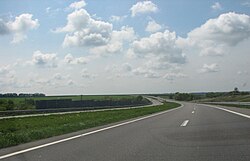
M 29 (Ukraine)
| M29 trunk road in Ukraine | |

|
|
| |
|
| Basic data | |
| Operator: | |
| Overall length: | 157.9 km |
|
Oblasts : |
|
|
Course of the road
|
|
The M 29 is a 157.9 km (with feeder to the M 18 160.7 km) long trunk road of "international importance" in the northeast of Ukraine .
The well-developed trunk road begins in the Kharkiv Oblast near the city of Ljubotyn west of Kharkiv as a junction of the M 03 and runs in a south-westerly direction past Nowa Wodolaha to Krasnohrad . Here it leads south to Pereschtschepyne in the north of Dnipropetrovsk Oblast , from where it again runs in a south-westerly direction past Holubiwka and ends at Hubynycha , about 20 kilometers north of Novomoskowsk , and merges into the M18 .
Web links
- M 29 trunk road on Google Maps
Individual evidence
- ^ List of public roads of national importance ; Cabinet of Ministers of Ukraine , Law No. 712 of September 16, 2015; accessed on August 30, 2017 (Ukrainian)
